Subic Bay Freeport Zone geodata
Subic Bay Freeport Zone (Central Luzon) is a seat of a third-order administrative division; located in Philippines in Asia/Manila (GMT+8) time zone. In our database, there are 4166 cities with bigger population. Compared to other cities in Philippines, 75.7% of cities are located further ↓South; 95.6% of cities are located further →East and 83.3% of cities have lower elevation than Subic Bay Freeport Zone. Note1
Administrative division(s):
- Level 1: Central Luzon
- Level 2: Province of Zambales
- Level 3: Olongapo City
Current local time in Subic Bay Freeport Zone:
01:52 AM, TuesdayDifference from your time zone: hours


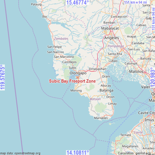
Subic Bay Freeport Zone GPS coordinates[2]
14° 47' 20.364" North, 120° 16' 47.532" East
| Map corner | latitude | longitude |
|---|---|---|
| Upper-left | 15.46774°, | 119.57675° |
| Center: | 14.78899°, | 120.27987° |
| Lower-right: | 14.10811°, | 120.983° |
| Map W x H: | 151.2×151.2 km | = 94×94mi |
| max Lat: | 20.78733° ⇑24.3% North |
| Subic Bay Freeport Zone: | 14.78899° |
| min Lat: | ⇓75.7% South 4.65442° |
| min Long | Subic Bay Freep | max Long |
| 117.04868° | 120.27987° | 126.58417° |
| W 4.4%⇐ | ⇒95.6% E |
Elevation
Elevation of Subic Bay Freeport Zone is 118 m = 387 ft, and this is 30.1 m = 99 ft above average elevation for this country.
| Max E: |
2262 m = 7421 ft | 16.7% |
| Subic Bay Freeport Zone | 118 m 387 ft | |
| Avg. | 87.9 m = 288 ft | |
Min E: |
-2 m = -7 ft | 83.3% |
See also: Philippines elevation on elevation.city.
Geographical zone
Subic Bay Freeport Zone is located in North Torrid zone (between Equator and Tropic of Cancer). Distance of this Northern Tropic circle is 961.5 km =597.4 mi to North.| Distance of | km | miles | from Subic Bay Freeport Zone |
|---|---|---|---|
| North Pole | 8362.7 | 5196.3 | to North |
| Arctic Circle | 5756.8 | 3577.1 | to North |
| Tropic Cancer | 961.5 | 597.4 | to North |
| Equator | 1644.4 | 1021.8 | to South |


Nearby cities:
15 places around Subic Bay Freeport Zone: (largest is in red/bold)
• Bagac
24.6 km =15.3 mi,  150°
150°
• Balsic
23.1 km =14.4 mi,  70°
70°
• Banawang
23 km =14.3 mi, 148°
• Castillejos
18.3 km =11.4 mi,  331°
331°
• Dinalupihan
21 km =13 mi,  61°
61°
• Hermosa
25 km =15.5 mi,  79°
79°
• Mabayo
6.4 km =4 mi,  181°
181°
• Morong
12.3 km =7.6 mi,  186°
186°
• Olongapo
4.5 km =2.8 mi,  4°
4°
• Pamatawan
17 km =10.6 mi,  335°
335°
• Sabang
10.9 km =6.8 mi,  196°
196°
• San Agustin
21.3 km =13.2 mi,  318°
318°
• San Benito
17.3 km =10.7 mi, 66°
• San Marcelino
24.4 km =15.2 mi, 327°
• Subic
11.2 km =7 mi, 332°
Sources, notices
• [Note1] Compared only with cities in Philippines existing in our database
• [Src1] Map data: © OpenStreetMap contributors (CC-BY-SA)
• [Src2] Other city data from geonames.org with taken over terms of usage.
• [Src3] Geographical zone / Annual Mean Temperature by Robert A. Rohde @ Wikipedia
