Morong geodata
Morong (Central Luzon) is a seat of a third-order administrative division; located in Philippines in Asia/Manila (GMT+8) time zone. With population of 16,117 people, there are 423 cities with bigger population in this country. Compared to other cities in Philippines, 75.1% of cities are located further ↓South; 95.7% of cities are located further →East and 76.6% of cities have higher elevation than Morong. Note1


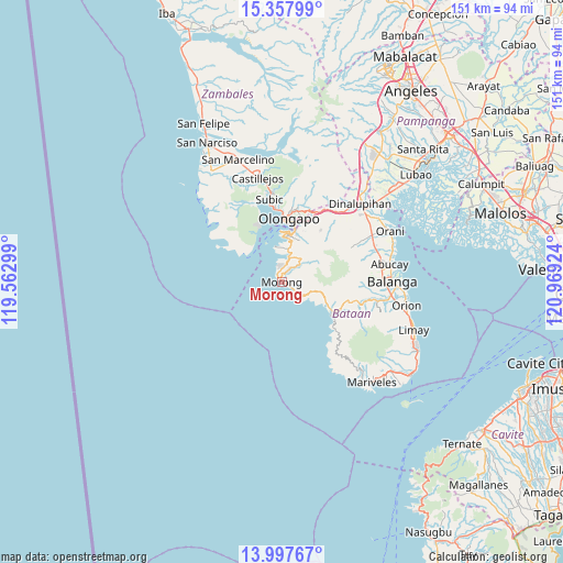
Morong GPS coordinates[2]
14° 40' 44.004" North, 120° 15' 57.996" East
| Map corner | latitude | longitude |
|---|---|---|
| Upper-left | 15.35799°, | 119.56299° |
| Center: | 14.67889°, | 120.26611° |
| Lower-right: | 13.99767°, | 120.96924° |
| Map W x H: | 151.3×151.3 km | = 94×94mi |
| max Lat: | 20.78733° ⇑24.9% North |
| Morong: | 14.67889° |
| min Lat: | ⇓75.1% South 4.65442° |
| min Long | Morong | max Long |
| 117.04868° | 120.26611° | 126.58417° |
| W 4.3%⇐ | ⇒95.7% E |
Elevation
Elevation of Morong is 10 m = 33 ft, and this is 77.9 m = 256 ft below average elevation for this country.
| Max E: |
2262 m = 7421 ft | 76.6% |
| Avg. | 87.9 m = 288 ft | |
| Morong | 10 m = 33 ft | |
Min E: |
-2 m = -7 ft | 23.4% |
See also: Philippines elevation on elevation.city.
Geographical zone
Morong is located in North Torrid zone (between Equator and Tropic of Cancer). Distance of this Northern Tropic circle is 973.8 km =605.1 mi to North.| Distance of | km | miles | from Morong |
|---|---|---|---|
| North Pole | 8374.9 | 5203.9 | to North |
| Arctic Circle | 5769 | 3584.7 | to North |
| Tropic Cancer | 973.8 | 605.1 | to North |
| Equator | 1632.1 | 1014.1 | to South |


Nearby cities:
15 places around Morong: (largest is in red/bold)
• Abucay
29.4 km =18.3 mi,  78°
78°
• Bagac
16.4 km =10.2 mi,  124°
124°
• Balanga
29 km =18 mi,  90°
90°
• Banawang
15.3 km =9.5 mi, 119°
• Castillejos
29.3 km =18.2 mi,  345°
345°
• Dinalupihan
29.9 km =18.6 mi,  42°
42°
• Mabayo
6 km =3.7 mi,  12°
12°
• Olongapo
16.8 km =10.4 mi, 6°
• Pamatawan
28.2 km =17.5 mi, 348°
• Parang
20.4 km =12.7 mi,  104°
104°
• Sabang
2.4 km =1.5 mi,  317°
317°
• San Benito
25.8 km =16 mi, 42°
• Saysain
18.9 km =11.7 mi,  133°
133°
• Subic
22.5 km =14 mi, 350°
• Subic Bay Freeport Zone
12.3 km =7.6 mi, 6°
Sources, notices
• [Note1] Compared only with cities in Philippines existing in our database
• [Src1] Map data: © OpenStreetMap contributors (CC-BY-SA)
• [Src2] Other city data from geonames.org with taken over terms of usage.
• [Src3] Geographical zone / Annual Mean Temperature by Robert A. Rohde @ Wikipedia
