Balite Segundo geodata
Balite Segundo (Calabarzon) is a populated place; located in Philippines in Asia/Manila (GMT+8) time zone. With population of 7,495 people, there are 829 cities with bigger population in this country. Compared to other cities in Philippines, 71.5% of cities are located further ↓South; 77% of cities are located further →East and 94.7% of cities have lower elevation than Balite Segundo. Note1


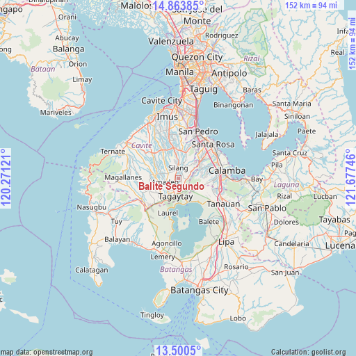
Balite Segundo GPS coordinates[2]
14° 10' 59.52" North, 120° 58' 27.588" East
| Map corner | latitude | longitude |
|---|---|---|
| Upper-left | 14.86385°, | 120.27121° |
| Center: | 14.1832°, | 120.97433° |
| Lower-right: | 13.5005°, | 121.67746° |
| Map W x H: | 151.6×151.6 km | = 94.2×94.2mi |
| max Lat: | 20.78733° ⇑28.5% North |
| Balite Segundo: | 14.1832° |
| min Lat: | ⇓71.5% South 4.65442° |
| min Long | Balite Segundo | max Long |
| 117.04868° | 120.97433° | 126.58417° |
| W 23%⇐ | ⇒77% E |
Elevation
Elevation of Balite Segundo is 396 m = 1299 ft, and this is 308.1 m = 1011 ft above average elevation for this country.
| Max E: |
2262 m = 7421 ft | 5.3% |
| Balite Segundo | 396 m 1299 ft | |
| Avg. | 87.9 m = 288 ft | |
Min E: |
-2 m = -7 ft | 94.7% |
See also: Philippines elevation on elevation.city.
Geographical zone
Balite Segundo is located in North Torrid zone (between Equator and Tropic of Cancer). Distance of this Northern Tropic circle is 1028.9 km =639.3 mi to North.| Distance of | km | miles | from Balite Segundo |
|---|---|---|---|
| North Pole | 8430 | 5238.2 | to North |
| Arctic Circle | 5824.2 | 3619 | to North |
| Tropic Cancer | 1028.9 | 639.3 | to North |
| Equator | 1577 | 979.9 | to South |


Nearby cities:
15 places around Balite Segundo: (largest is in red/bold)
• Amadeo
5.6 km =3.5 mi,  255°
255°
• Biga
8.3 km =5.2 mi,  358°
358°
• Bulihan
10.8 km =6.7 mi,  11°
11°
• Indang
10.6 km =6.6 mi,  277°
277°
• Javalera
10.5 km =6.5 mi,  322°
322°
• Lumil
3.8 km =2.4 mi,  92°
92°
• Maguyam
9.4 km =5.8 mi,  20°
20°
• Malabag
3.3 km =2.1 mi,  197°
197°
• Mendez-Nuñez
9.6 km =6 mi,  230°
230°
• Pangil
7.4 km =4.6 mi,  285°
285°
• Patuto
7.4 km =4.6 mi,  186°
186°
• Puting Kahoy
7.1 km =4.4 mi,  59°
59°
• Sampaloc
10.6 km =6.6 mi,  181°
181°
• Silang
3.6 km =2.2 mi,  354°
354°
• Tagaytay
10.7 km =6.6 mi, 204°
Sources, notices
• [Note1] Compared only with cities in Philippines existing in our database
• [Src1] Map data: © OpenStreetMap contributors (CC-BY-SA)
• [Src2] Other city data from geonames.org with taken over terms of usage.
• [Src3] Geographical zone / Annual Mean Temperature by Robert A. Rohde @ Wikipedia
