Pangil geodata
Pangil (Calabarzon) is a populated place; located in Philippines in Asia/Manila (GMT+8) time zone. With population of 2,455 people, there are 3373 cities with bigger population in this country. Compared to other cities in Philippines, 72% of cities are located further ↓South; 79.1% of cities are located further →East and 93% of cities have lower elevation than Pangil. Note1


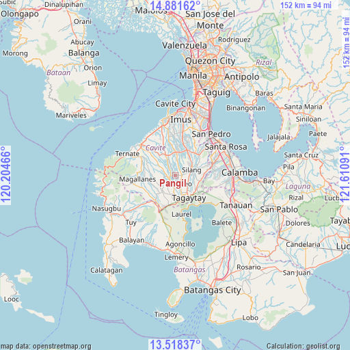
Pangil GPS coordinates[2]
14° 12' 3.672" North, 120° 54' 28.008" East
| Map corner | latitude | longitude |
|---|---|---|
| Upper-left | 14.88162°, | 120.20466° |
| Center: | 14.20102°, | 120.90778° |
| Lower-right: | 13.51837°, | 121.61091° |
| Map W x H: | 151.6×151.6 km | = 94.2×94.2mi |
| max Lat: | 20.78733° ⇑28% North |
| Pangil: | 14.20102° |
| min Lat: | ⇓72% South 4.65442° |
| min Long | Pangil | max Long |
| 117.04868° | 120.90778° | 126.58417° |
| W 20.9%⇐ | ⇒79.1% E |
Elevation
Elevation of Pangil is 327 m = 1073 ft, and this is 239.1 m = 784 ft above average elevation for this country.
| Max E: |
2262 m = 7421 ft | 7% |
| Pangil | 327 m 1073 ft | |
| Avg. | 87.9 m = 288 ft | |
Min E: |
-2 m = -7 ft | 93% |
See also: Philippines elevation on elevation.city.
Geographical zone
Pangil is located in North Torrid zone (between Equator and Tropic of Cancer). Distance of this Northern Tropic circle is 1026.9 km =638.1 mi to North.| Distance of | km | miles | from Pangil |
|---|---|---|---|
| North Pole | 8428.1 | 5237 | to North |
| Arctic Circle | 5822.2 | 3617.7 | to North |
| Tropic Cancer | 1026.9 | 638.1 | to North |
| Equator | 1579 | 981.1 | to South |


Nearby cities:
15 places around Pangil: (largest is in red/bold)
• Alfonso
8.9 km =5.5 mi,  220°
220°
• Aliang
9.5 km =5.9 mi,  343°
343°
• Amadeo
3.8 km =2.4 mi,  153°
153°
• Anuling
8.7 km =5.4 mi,  191°
191°
• Balite Segundo
7.4 km =4.6 mi,  105°
105°
• Banaba
6.5 km =4 mi,  285°
285°
• Biga
9.3 km =5.8 mi,  47°
47°
• Bitangan
6.7 km =4.2 mi,  331°
331°
• Guyam Malaki
7.4 km =4.6 mi, 223°
• Indang
3.4 km =2.1 mi,  259°
259°
• Javalera
6.4 km =4 mi,  7°
7°
• Malabag
8 km =5 mi,  129°
129°
• Mendez-Nuñez
8.1 km =5 mi,  181°
181°
• Silang
7 km =4.3 mi,  76°
76°
• Taywanak Ilaya
8.2 km =5.1 mi,  233°
233°
Sources, notices
• [Note1] Compared only with cities in Philippines existing in our database
• [Src1] Map data: © OpenStreetMap contributors (CC-BY-SA)
• [Src2] Other city data from geonames.org with taken over terms of usage.
• [Src3] Geographical zone / Annual Mean Temperature by Robert A. Rohde @ Wikipedia
