Balangkayan geodata
Balangkayan (Eastern Visayas) is a populated place; located in Philippines in Asia/Manila (GMT+8) time zone. With population of 3,159 people, there are 2343 cities with bigger population in this country. Compared to other cities in Philippines, 51.8% of cities are located further ↑North; 93.6% of cities are located further ←West and 89.7% of cities have higher elevation than Balangkayan. Note1
Administrative division(s):
- Level 1: Eastern Visayas
- Level 2: Province of Eastern Samar
- Level 3: Balangkayan


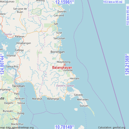
Balangkayan GPS coordinates[2]
11° 28' 17.004" North, 125° 30' 38.016" East
| Map corner | latitude | longitude |
|---|---|---|
| Upper-left | 12.15961°, | 124.80744° |
| Center: | 11.47139°, | 125.51056° |
| Lower-right: | 10.78149°, | 126.21369° |
| Map W x H: | 153.2×153.2 km | = 95.2×95.2mi |
| max Lat: | 20.78733° ⇑51.8% North |
| Balangkayan: | 11.47139° |
| min Lat: | ⇓48.2% South 4.65442° |
| min Long | Balangkayan | max Long |
| 117.04868° | 125.51056° | 126.58417° |
| W 93.6%⇐ | ⇒6.4% E |
Elevation
Elevation of Balangkayan is 7 m = 23 ft, and this is 80.9 m = 265 ft below average elevation for this country.
| Max E: |
2262 m = 7421 ft | 89.7% |
| Avg. | 87.9 m = 288 ft | |
| Balangkayan | 7 m = 23 ft | |
Min E: |
-2 m = -7 ft | 10.3% |
See also: Philippines elevation on elevation.city.
Geographical zone
Balangkayan is located in North Torrid zone (between Equator and Tropic of Cancer). Distance of Equator is 1275.5 km =792.6 mi to South.| Distance of | km | miles | from Balangkayan |
|---|---|---|---|
| North Pole | 8731.6 | 5425.6 | to North |
| Arctic Circle | 6125.7 | 3806.3 | to North |
| Tropic Cancer | 1330.4 | 826.7 | to North |
| Equator | 1275.5 | 792.6 | to South |


Nearby cities:
15 places around Balangkayan: (largest is in red/bold)
• Balud
18.2 km =11.3 mi,  332°
332°
• Borongan
17.4 km =10.8 mi, 330°
• Cabay
3.4 km =2.1 mi,  213°
213°
• General MacArthur
25.2 km =15.7 mi,  172°
172°
• Giporlos
39.6 km =24.6 mi,  189°
189°
• Hernani
20.1 km =12.5 mi,  143°
143°
• Lalauigan
13.8 km =8.6 mi,  341°
341°
• Llorente
7.6 km =4.7 mi,  149°
149°
• Mabini
38 km =23.6 mi,  260°
260°
• Maydolong
3.5 km =2.2 mi, 337°
• Maypangdan
21.1 km =13.1 mi, 341°
• Nena
34.3 km =21.3 mi, 342°
• Quinapundan
34.8 km =21.6 mi,  177°
177°
• San Julian
31.9 km =19.8 mi,  349°
349°
• Sulat
38.2 km =23.7 mi, 350°
Sources, notices
• [Note1] Compared only with cities in Philippines existing in our database
• [Src1] Map data: © OpenStreetMap contributors (CC-BY-SA)
• [Src2] Other city data from geonames.org with taken over terms of usage.
• [Src3] Geographical zone / Annual Mean Temperature by Robert A. Rohde @ Wikipedia
