San Julian geodata
San Julian (Eastern Visayas) is a seat of a third-order administrative division; located in Philippines in Asia/Manila (GMT+8) time zone. With population of 3,069 people, there are 2446 cities with bigger population in this country. Compared to other cities in Philippines, 50.7% of cities are located further ↓South; 92.9% of cities are located further ←West and 50.3% of cities have higher elevation than San Julian. Note1
Administrative division(s):
- Level 1: Eastern Visayas
- Level 2: Province of Eastern Samar
- Level 3: San Julian


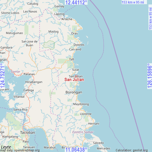
San Julian GPS coordinates[2]
11° 45' 12.996" North, 125° 27' 20.988" East
| Map corner | latitude | longitude |
|---|---|---|
| Upper-left | 12.44112°, | 124.75271° |
| Center: | 11.75361°, | 125.45583° |
| Lower-right: | 11.06438°, | 126.15896° |
| Map W x H: | 153.1×153.1 km | = 95.1×95.1mi |
| max Lat: | 20.78733° ⇑49.3% North |
| San Julian: | 11.75361° |
| min Lat: | ⇓50.7% South 4.65442° |
| min Long | San Julian | max Long |
| 117.04868° | 125.45583° | 126.58417° |
| W 92.9%⇐ | ⇒7.1% E |
Elevation
Elevation of San Julian is 23 m = 75 ft, and this is 64.9 m = 213 ft below average elevation for this country.
| Max E: |
2262 m = 7421 ft | 50.3% |
| Avg. | 87.9 m = 288 ft | |
| San Julian | 23 m = 75 ft | |
Min E: |
-2 m = -7 ft | 49.7% |
See also: Philippines elevation on elevation.city.
Geographical zone
San Julian is located in North Torrid zone (between Equator and Tropic of Cancer). Distance of this Northern Tropic circle is 1299 km =807.2 mi to North.| Distance of | km | miles | from San Julian |
|---|---|---|---|
| North Pole | 8700.2 | 5406.1 | to North |
| Arctic Circle | 6094.3 | 3786.8 | to North |
| Tropic Cancer | 1299 | 807.2 | to North |
| Equator | 1306.9 | 812.1 | to South |


Nearby cities:
15 places around San Julian: (largest is in red/bold)
• Balangkayan
31.9 km =19.8 mi,  169°
169°
• Balud
15.4 km =9.6 mi,  189°
189°
• Borongan
16.4 km =10.2 mi, 189°
• Cabay
34.5 km =21.4 mi, 173°
• Can-Avid
26.9 km =16.7 mi,  358°
358°
• Dao
38.5 km =23.9 mi, 356°
• Dapdap
34.5 km =21.4 mi,  5°
5°
• Dolores
31.7 km =19.7 mi, 5°
• Lalauigan
18.3 km =11.4 mi,  175°
175°
• Mantang
13.3 km =8.3 mi,  346°
346°
• Maydolong
28.5 km =17.7 mi, 170°
• Maypangdan
11.3 km =7 mi, 183°
• Nena
4.4 km =2.7 mi,  288°
288°
• Sulat
6.3 km =3.9 mi, 358°
• Taft
16.9 km =10.5 mi, 346°
Sources, notices
• [Note1] Compared only with cities in Philippines existing in our database
• [Src1] Map data: © OpenStreetMap contributors (CC-BY-SA)
• [Src2] Other city data from geonames.org with taken over terms of usage.
• [Src3] Geographical zone / Annual Mean Temperature by Robert A. Rohde @ Wikipedia
