Maydolong geodata
Maydolong (Eastern Visayas) is a populated place; located in Philippines in Asia/Manila (GMT+8) time zone. With population of 5,492 people, there are 1159 cities with bigger population in this country. Compared to other cities in Philippines, 51.3% of cities are located further ↑North; 93.5% of cities are located further ←West and 92.7% of cities have higher elevation than Maydolong. Note1
Administrative division(s):
- Level 1: Eastern Visayas
- Level 2: Province of Eastern Samar
- Level 3: Maydolong


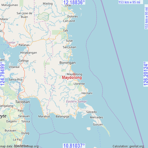
Maydolong GPS coordinates[2]
11° 30' 0.756" North, 125° 29' 53.196" East
| Map corner | latitude | longitude |
|---|---|---|
| Upper-left | 12.18836°, | 124.79499° |
| Center: | 11.50021°, | 125.49811° |
| Lower-right: | 10.81037°, | 126.20124° |
| Map W x H: | 153.2×153.2 km | = 95.2×95.2mi |
| max Lat: | 20.78733° ⇑51.3% North |
| Maydolong: | 11.50021° |
| min Lat: | ⇓48.7% South 4.65442° |
| min Long | Maydolong | max Long |
| 117.04868° | 125.49811° | 126.58417° |
| W 93.5%⇐ | ⇒6.5% E |
Elevation
Elevation of Maydolong is 6 m = 20 ft, and this is 81.9 m = 269 ft below average elevation for this country.
| Max E: |
2262 m = 7421 ft | 92.7% |
| Avg. | 87.9 m = 288 ft | |
| Maydolong | 6 m = 20 ft | |
Min E: |
-2 m = -7 ft | 7.3% |
See also: Philippines elevation on elevation.city.
Geographical zone
Maydolong is located in North Torrid zone (between Equator and Tropic of Cancer). Distance of Equator is 1278.7 km =794.5 mi to South.| Distance of | km | miles | from Maydolong |
|---|---|---|---|
| North Pole | 8728.4 | 5423.6 | to North |
| Arctic Circle | 6122.5 | 3804.3 | to North |
| Tropic Cancer | 1327.2 | 824.7 | to North |
| Equator | 1278.7 | 794.5 | to South |


Nearby cities:
15 places around Maydolong: (largest is in red/bold)
• Balangkayan
3.5 km =2.2 mi,  157°
157°
• Balud
14.7 km =9.1 mi,  331°
331°
• Borongan
14 km =8.7 mi, 328°
• Cabay
6.1 km =3.8 mi,  184°
184°
• General MacArthur
28.6 km =17.8 mi,  170°
170°
• Hernani
23.5 km =14.6 mi,  145°
145°
• Lalauigan
10.4 km =6.5 mi,  342°
342°
• Llorente
11.1 km =6.9 mi, 152°
• Mabini
37.3 km =23.2 mi,  255°
255°
• Mantang
41.8 km =26 mi,  349°
349°
• Maypangdan
17.7 km =11 mi, 342°
• Nena
30.8 km =19.1 mi, 343°
• Quinapundan
38.1 km =23.7 mi, 176°
• San Julian
28.5 km =17.7 mi, 350°
• Sulat
34.8 km =21.6 mi, 352°
Sources, notices
• [Note1] Compared only with cities in Philippines existing in our database
• [Src1] Map data: © OpenStreetMap contributors (CC-BY-SA)
• [Src2] Other city data from geonames.org with taken over terms of usage.
• [Src3] Geographical zone / Annual Mean Temperature by Robert A. Rohde @ Wikipedia
