Maypangdan geodata
Maypangdan (Eastern Visayas) is a populated place; located in Philippines in Asia/Manila (GMT+8) time zone. With population of 2,342 people, there are 3580 cities with bigger population in this country. Compared to other cities in Philippines, 50.1% of cities are located further ↓South; 92.9% of cities are located further ←West and 92.7% of cities have higher elevation than Maypangdan. Note1
Administrative division(s):
- Level 1: Eastern Visayas
- Level 2: Province of Eastern Samar
- Level 3: City of Borongan


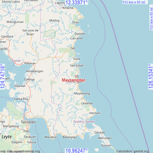
Maypangdan GPS coordinates[2]
11° 39' 6.984" North, 125° 27' 1.008" East
| Map corner | latitude | longitude |
|---|---|---|
| Upper-left | 12.33971°, | 124.74716° |
| Center: | 11.65194°, | 125.45028° |
| Lower-right: | 10.96247°, | 126.15341° |
| Map W x H: | 153.1×153.1 km | = 95.1×95.1mi |
| max Lat: | 20.78733° ⇑49.9% North |
| Maypangdan: | 11.65194° |
| min Lat: | ⇓50.1% South 4.65442° |
| min Long | Maypangdan | max Long |
| 117.04868° | 125.45028° | 126.58417° |
| W 92.9%⇐ | ⇒7.1% E |
Elevation
Elevation of Maypangdan is 6 m = 20 ft, and this is 81.9 m = 269 ft below average elevation for this country.
| Max E: |
2262 m = 7421 ft | 92.7% |
| Avg. | 87.9 m = 288 ft | |
| Maypangdan | 6 m = 20 ft | |
Min E: |
-2 m = -7 ft | 7.3% |
See also: Philippines elevation on elevation.city.
Geographical zone
Maypangdan is located in North Torrid zone (between Equator and Tropic of Cancer). Distance of Equator is 1295.6 km =805 mi to South.| Distance of | km | miles | from Maypangdan |
|---|---|---|---|
| North Pole | 8711.5 | 5413.1 | to North |
| Arctic Circle | 6105.6 | 3793.8 | to North |
| Tropic Cancer | 1310.3 | 814.2 | to North |
| Equator | 1295.6 | 805 | to South |


Nearby cities:
15 places around Maypangdan: (largest is in red/bold)
• Balangkayan
21.1 km =13.1 mi,  161°
161°
• Balud
4.3 km =2.7 mi,  205°
205°
• Borongan
5.3 km =3.3 mi,  202°
202°
• Cabay
23.4 km =14.5 mi,  168°
168°
• Can-Avid
38.2 km =23.7 mi,  359°
359°
• Hernani
40.7 km =25.3 mi,  153°
153°
• Lalauigan
7.3 km =4.5 mi, 163°
• Llorente
28.6 km =17.8 mi, 158°
• Mabini
40.5 km =25.2 mi,  229°
229°
• Mantang
24.4 km =15.2 mi,  354°
354°
• Maydolong
17.7 km =11 mi, 162°
• Nena
13.1 km =8.1 mi,  344°
344°
• San Julian
11.3 km =7 mi,  3°
3°
• Sulat
17.6 km =10.9 mi, 1°
• Taft
27.9 km =17.3 mi, 352°
Sources, notices
• [Note1] Compared only with cities in Philippines existing in our database
• [Src1] Map data: © OpenStreetMap contributors (CC-BY-SA)
• [Src2] Other city data from geonames.org with taken over terms of usage.
• [Src3] Geographical zone / Annual Mean Temperature by Robert A. Rohde @ Wikipedia
