Balagunan geodata
Balagunan (Davao) is a populated place; located in Philippines in Asia/Manila (GMT+8) time zone. With population of 4,528 people, there are 1478 cities with bigger population in this country. Compared to other cities in Philippines, 87.1% of cities are located further ↑North; 93.7% of cities are located further ←West and 81.7% of cities have lower elevation than Balagunan. Note1


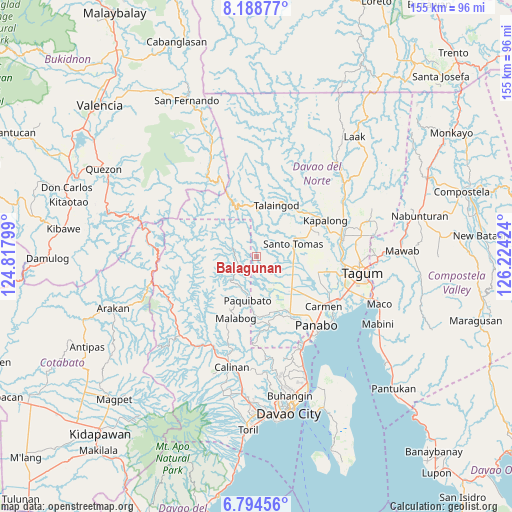
Balagunan GPS coordinates[2]
7° 29' 31.992" North, 125° 31' 15.996" East
| Map corner | latitude | longitude |
|---|---|---|
| Upper-left | 8.18877°, | 124.81799° |
| Center: | 7.49222°, | 125.52111° |
| Lower-right: | 6.79456°, | 126.22424° |
| Map W x H: | 155×155 km | = 96.3×96.3mi |
| max Lat: | 20.78733° ⇑87.1% North |
| Balagunan: | 7.49222° |
| min Lat: | ⇓12.9% South 4.65442° |
| min Long | Balagunan | max Long |
| 117.04868° | 125.52111° | 126.58417° |
| W 93.7%⇐ | ⇒6.3% E |
Elevation
Elevation of Balagunan is 104 m = 341 ft, and this is 16.1 m = 53 ft above average elevation for this country.
| Max E: |
2262 m = 7421 ft | 18.3% |
| Balagunan | 104 m 341 ft | |
| Avg. | 87.9 m = 288 ft | |
Min E: |
-2 m = -7 ft | 81.7% |
See also: Philippines elevation on elevation.city.
Geographical zone
Balagunan is located in North Torrid zone (between Equator and Tropic of Cancer). Distance of Equator is 833.1 km =517.7 mi to South.| Distance of | km | miles | from Balagunan |
|---|---|---|---|
| North Pole | 9174 | 5700.5 | to North |
| Arctic Circle | 6568.1 | 4081.2 | to North |
| Tropic Cancer | 1772.9 | 1101.6 | to North |
| Equator | 833.1 | 517.7 | to South |


Nearby cities:
15 places around Balagunan: (largest is in red/bold)
• Alejal
19.5 km =12.1 mi,  128°
128°
• Kinamayan
16.8 km =10.4 mi,  87°
87°
• La Libertad
14 km =8.7 mi,  95°
95°
• Luna
18.6 km =11.6 mi,  59°
59°
• Lungaog
18.8 km =11.7 mi,  77°
77°
• Mabuhay
17.9 km =11.1 mi,  170°
170°
• Magsaysay
16.4 km =10.2 mi, 130°
• Manay
17.8 km =11.1 mi,  160°
160°
• New Visayas
11.8 km =7.3 mi,  72°
72°
• Sampao
19.1 km =11.9 mi,  53°
53°
• San Miguel
17.1 km =10.6 mi, 92°
• Santo Niño
18.6 km =11.6 mi,  38°
38°
• Santo Tomas
12.2 km =7.6 mi, 67°
• Simod
20 km =12.4 mi,  264°
264°
• Tubod
19.1 km =11.9 mi, 134°
Sources, notices
• [Note1] Compared only with cities in Philippines existing in our database
• [Src1] Map data: © OpenStreetMap contributors (CC-BY-SA)
• [Src2] Other city data from geonames.org with taken over terms of usage.
• [Src3] Geographical zone / Annual Mean Temperature by Robert A. Rohde @ Wikipedia
