Mabuhay geodata
Mabuhay (Davao) is a populated place; located in Philippines in Asia/Manila (GMT+8) time zone. With population of 2,134 people, there are 4024 cities with bigger population in this country. Compared to other cities in Philippines, 88.3% of cities are located further ↑North; 94% of cities are located further ←West and 67.5% of cities have lower elevation than Mabuhay. Note1


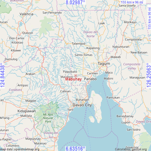
Mabuhay GPS coordinates[2]
7° 19' 59.016" North, 125° 32' 51" East
| Map corner | latitude | longitude |
|---|---|---|
| Upper-left | 8.02987°, | 124.84438° |
| Center: | 7.33306°, | 125.5475° |
| Lower-right: | 6.63516°, | 126.25063° |
| Map W x H: | 155.1×155.1 km | = 96.4×96.4mi |
| max Lat: | 20.78733° ⇑88.3% North |
| Mabuhay: | 7.33306° |
| min Lat: | ⇓11.7% South 4.65442° |
| min Long | Mabuhay | max Long |
| 117.04868° | 125.5475° | 126.58417° |
| W 94%⇐ | ⇒6% E |
Elevation
Elevation of Mabuhay is 47 m = 154 ft, and this is 40.9 m = 134 ft below average elevation for this country.
| Max E: |
2262 m = 7421 ft | 32.5% |
| Avg. | 87.9 m = 288 ft | |
| Mabuhay | 47 m = 154 ft | |
Min E: |
-2 m = -7 ft | 67.5% |
See also: Philippines elevation on elevation.city.
Geographical zone
Mabuhay is located in North Torrid zone (between Equator and Tropic of Cancer). Distance of Equator is 815.4 km =506.7 mi to South.| Distance of | km | miles | from Mabuhay |
|---|---|---|---|
| North Pole | 9191.7 | 5711.5 | to North |
| Arctic Circle | 6585.8 | 4092.2 | to North |
| Tropic Cancer | 1790.6 | 1112.6 | to North |
| Equator | 815.4 | 506.7 | to South |


Nearby cities:
15 places around Mabuhay: (largest is in red/bold)
• Alejal
13.6 km =8.5 mi,  65°
65°
• Carmen
17.8 km =11.1 mi,  80°
80°
• Dacudao
15.6 km =9.7 mi,  212°
212°
• Katipunan
8.2 km =5.1 mi,  100°
100°
• Lacson
17.8 km =11.1 mi,  220°
220°
• Lasang
14.9 km =9.3 mi,  119°
119°
• Maduao
9.7 km =6 mi, 116°
• Magsaysay
12 km =7.5 mi,  53°
53°
• Mahayag
15.2 km =9.4 mi,  148°
148°
• Manaloal
13 km =8.1 mi, 73°
• Manay
3.2 km =2 mi, 72°
• Nanyo
10 km =6.2 mi,  90°
90°
• Panabo
15.3 km =9.5 mi, 100°
• Santo Niño
17.4 km =10.8 mi, 91°
• Tubod
11.5 km =7.1 mi, 68°
Sources, notices
• [Note1] Compared only with cities in Philippines existing in our database
• [Src1] Map data: © OpenStreetMap contributors (CC-BY-SA)
• [Src2] Other city data from geonames.org with taken over terms of usage.
• [Src3] Geographical zone / Annual Mean Temperature by Robert A. Rohde @ Wikipedia
