Magsaysay geodata
Magsaysay (Davao) is a populated place; located in Philippines in Asia/Manila (GMT+8) time zone. With population of 4,001 people, there are 1729 cities with bigger population in this country. Compared to other cities in Philippines, 87.8% of cities are located further ↑North; 94.9% of cities are located further ←West and 65.1% of cities have higher elevation than Magsaysay. Note1


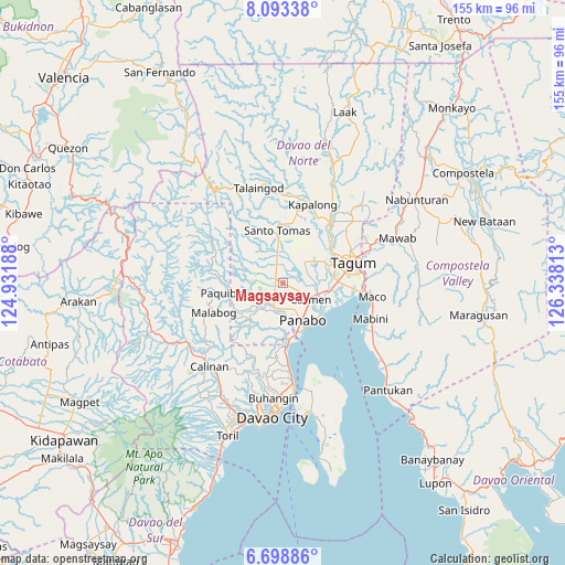
Magsaysay GPS coordinates[2]
7° 23' 48.012" North, 125° 38' 6" East
| Map corner | latitude | longitude |
|---|---|---|
| Upper-left | 8.09338°, | 124.93188° |
| Center: | 7.39667°, | 125.635° |
| Lower-right: | 6.69886°, | 126.33813° |
| Map W x H: | 155.1×155.1 km | = 96.4×96.4mi |
| max Lat: | 20.78733° ⇑87.8% North |
| Magsaysay: | 7.39667° |
| min Lat: | ⇓12.2% South 4.65442° |
| min Long | Magsaysay | max Long |
| 117.04868° | 125.635° | 126.58417° |
| W 94.9%⇐ | ⇒5.1% E |
Elevation
Elevation of Magsaysay is 14 m = 46 ft, and this is 73.9 m = 242 ft below average elevation for this country.
| Max E: |
2262 m = 7421 ft | 65.1% |
| Avg. | 87.9 m = 288 ft | |
| Magsaysay | 14 m = 46 ft | |
Min E: |
-2 m = -7 ft | 34.9% |
See also: Philippines elevation on elevation.city.
Geographical zone
Magsaysay is located in North Torrid zone (between Equator and Tropic of Cancer). Distance of Equator is 822.4 km =511 mi to South.| Distance of | km | miles | from Magsaysay |
|---|---|---|---|
| North Pole | 9184.6 | 5707 | to North |
| Arctic Circle | 6578.7 | 4087.8 | to North |
| Tropic Cancer | 1783.5 | 1108.2 | to North |
| Equator | 822.4 | 511 | to South |


Nearby cities:
15 places around Magsaysay: (largest is in red/bold)
• Alejal
3.1 km =1.9 mi,  116°
116°
• Anibongan
9.3 km =5.8 mi,  92°
92°
• Cabayangan
10.9 km =6.8 mi,  83°
83°
• Carmen
8.8 km =5.5 mi, 117°
• Katipunan
8.6 km =5.3 mi,  190°
190°
• La Libertad
9.4 km =5.8 mi,  8°
8°
• Maduao
11.4 km =7.1 mi, 185°
• Manaloal
4.4 km =2.7 mi,  140°
140°
• Manay
9 km =5.6 mi,  227°
227°
• Nanyo
7.1 km =4.4 mi,  177°
177°
• Panabo
11.2 km =7 mi,  151°
151°
• San Miguel
10.8 km =6.7 mi,  24°
24°
• Santo Niño
10.9 km =6.8 mi,  134°
134°
• Tubod
3 km =1.9 mi,  158°
158°
• Tuganay
10.2 km =6.3 mi,  107°
107°
Sources, notices
• [Note1] Compared only with cities in Philippines existing in our database
• [Src1] Map data: © OpenStreetMap contributors (CC-BY-SA)
• [Src2] Other city data from geonames.org with taken over terms of usage.
• [Src3] Geographical zone / Annual Mean Temperature by Robert A. Rohde @ Wikipedia
