Simod geodata
Simod (Davao) is a populated place; located in Philippines in Asia/Manila (GMT+8) time zone. With population of 5,068 people, there are 1272 cities with bigger population in this country. Compared to other cities in Philippines, 87.3% of cities are located further ↑North; 91.6% of cities are located further ←West and 93.2% of cities have lower elevation than Simod. Note1


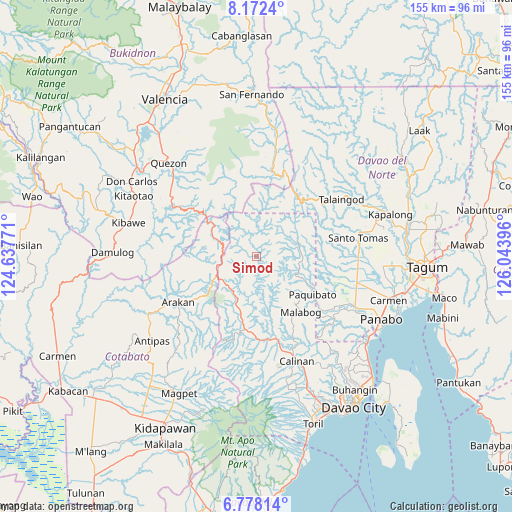
Simod GPS coordinates[2]
7° 28' 32.988" North, 125° 20' 26.988" East
| Map corner | latitude | longitude |
|---|---|---|
| Upper-left | 8.1724°, | 124.63771° |
| Center: | 7.47583°, | 125.34083° |
| Lower-right: | 6.77814°, | 126.04396° |
| Map W x H: | 155×155 km | = 96.3×96.3mi |
| max Lat: | 20.78733° ⇑87.3% North |
| Simod: | 7.47583° |
| min Lat: | ⇓12.7% South 4.65442° |
| min Long | Simod | max Long |
| 117.04868° | 125.34083° | 126.58417° |
| W 91.6%⇐ | ⇒8.4% E |
Elevation
Elevation of Simod is 334 m = 1096 ft, and this is 246.1 m = 807 ft above average elevation for this country.
| Max E: |
2262 m = 7421 ft | 6.8% |
| Simod | 334 m 1096 ft | |
| Avg. | 87.9 m = 288 ft | |
Min E: |
-2 m = -7 ft | 93.2% |
See also: Philippines elevation on elevation.city.
Geographical zone
Simod is located in North Torrid zone (between Equator and Tropic of Cancer). Distance of Equator is 831.2 km =516.5 mi to South.| Distance of | km | miles | from Simod |
|---|---|---|---|
| North Pole | 9175.8 | 5701.6 | to North |
| Arctic Circle | 6569.9 | 4082.3 | to North |
| Tropic Cancer | 1774.7 | 1102.7 | to North |
| Equator | 831.2 | 516.5 | to South |


Nearby cities:
15 places around Simod: (largest is in red/bold)
• Balagunan
20 km =12.4 mi,  84°
84°
• Dacudao
32.4 km =20.1 mi,  153°
153°
• Dalorong
26 km =16.2 mi,  298°
298°
• Gumalang
30.5 km =19 mi,  166°
166°
• Kibureau
27.4 km =17 mi,  334°
334°
• Kitobo
28.2 km =17.5 mi,  292°
292°
• Lacson
31.4 km =19.5 mi,  159°
159°
• Mabuhay
27.8 km =17.3 mi,  124°
124°
• Magsaysay
33.6 km =20.9 mi,  105°
105°
• Manay
29.8 km =18.5 mi, 120°
• New Visayas
31.6 km =19.6 mi, 80°
• Santo Tomas
31.8 km =19.8 mi, 78°
• Tamugan
27.5 km =17.1 mi, 171°
• Tuli
28.2 km =17.5 mi, 162°
• Wines
31.8 km =19.8 mi, 170°
Sources, notices
• [Note1] Compared only with cities in Philippines existing in our database
• [Src1] Map data: © OpenStreetMap contributors (CC-BY-SA)
• [Src2] Other city data from geonames.org with taken over terms of usage.
• [Src3] Geographical zone / Annual Mean Temperature by Robert A. Rohde @ Wikipedia
