Bagabag geodata
Bagabag (Cagayan Valley) is a seat of a third-order administrative division; located in Philippines in Asia/Manila (GMT+8) time zone. In our database, there are 4166 cities with bigger population. Compared to other cities in Philippines, 91.5% of cities are located further ↓South; 70.8% of cities are located further →East and 90% of cities have lower elevation than Bagabag. Note1
Administrative division(s):
- Level 1: Cagayan Valley
- Level 2: Province of Nueva Vizcaya
- Level 3: Bagabag


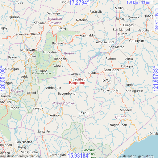
Bagabag GPS coordinates[2]
16° 36' 24.48" North, 121° 15' 15.12" East
| Map corner | latitude | longitude |
|---|---|---|
| Upper-left | 17.2794°, | 120.55108° |
| Center: | 16.6068°, | 121.2542° |
| Lower-right: | 15.93184°, | 121.95733° |
| Map W x H: | 149.8×149.8 km | = 93.1×93.1mi |
| max Lat: | 20.78733° ⇑8.5% North |
| Bagabag: | 16.6068° |
| min Lat: | ⇓91.5% South 4.65442° |
| min Long | Bagabag | max Long |
| 117.04868° | 121.2542° | 126.58417° |
| W 29.2%⇐ | ⇒70.8% E |
Elevation
Elevation of Bagabag is 228 m = 748 ft, and this is 140.1 m = 460 ft above average elevation for this country.
| Max E: |
2262 m = 7421 ft | 10% |
| Bagabag | 228 m 748 ft | |
| Avg. | 87.9 m = 288 ft | |
Min E: |
-2 m = -7 ft | 90% |
See also: Philippines elevation on elevation.city.
Geographical zone
Bagabag is located in North Torrid zone (between Equator and Tropic of Cancer). Distance of this Northern Tropic circle is 759.4 km =471.9 mi to North.| Distance of | km | miles | from Bagabag |
|---|---|---|---|
| North Pole | 8160.6 | 5070.8 | to North |
| Arctic Circle | 5554.7 | 3451.5 | to North |
| Tropic Cancer | 759.4 | 471.9 | to North |
| Equator | 1846.5 | 1147.4 | to South |


Nearby cities:
15 places around Bagabag: (largest is in red/bold)
• Baggabag B
13.1 km =8.1 mi,  211°
211°
• Baguinge
24.7 km =15.3 mi,  320°
320°
• Bayombong
17.9 km =11.1 mi,  218°
218°
• Bintawan
7.9 km =4.9 mi,  244°
244°
• Buliwao
13.9 km =8.6 mi,  189°
189°
• Busilak
20 km =12.4 mi, 223°
• Cordon
23.8 km =14.8 mi,  71°
71°
• Diadi
17.3 km =10.7 mi,  40°
40°
• Ibung
7.3 km =4.5 mi,  272°
272°
• Lamut
5.7 km =3.5 mi,  326°
326°
• Quezon
11.9 km =7.4 mi,  173°
173°
• Solano
12.5 km =7.8 mi, 218°
• Tuao
2.1 km =1.3 mi, 169°
• Uddiawan
12.2 km =7.6 mi, 244°
• Villa Verde
7.1 km =4.4 mi,  262°
262°
Sources, notices
• [Note1] Compared only with cities in Philippines existing in our database
• [Src1] Map data: © OpenStreetMap contributors (CC-BY-SA)
• [Src2] Other city data from geonames.org with taken over terms of usage.
• [Src3] Geographical zone / Annual Mean Temperature by Robert A. Rohde @ Wikipedia
