Lamut geodata
Lamut (Cordillera) is a seat of a third-order administrative division; located in Philippines in Asia/Manila (GMT+8) time zone. With population of 4,089 people, there are 1671 cities with bigger population in this country. Compared to other cities in Philippines, 91.6% of cities are located further ↓South; 71.2% of cities are located further →East and 89.6% of cities have lower elevation than Lamut. Note1


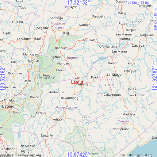
Lamut GPS coordinates[2]
16° 38' 56.652" North, 121° 13' 29.064" East
| Map corner | latitude | longitude |
|---|---|---|
| Upper-left | 17.32152°, | 120.52162° |
| Center: | 16.64907°, | 121.22474° |
| Lower-right: | 15.97425°, | 121.92787° |
| Map W x H: | 149.8×149.8 km | = 93.1×93.1mi |
| max Lat: | 20.78733° ⇑8.4% North |
| Lamut: | 16.64907° |
| min Lat: | ⇓91.6% South 4.65442° |
| min Long | Lamut | max Long |
| 117.04868° | 121.22474° | 126.58417° |
| W 28.8%⇐ | ⇒71.2% E |
Elevation
Elevation of Lamut is 220 m = 722 ft, and this is 132.1 m = 433 ft above average elevation for this country.
| Max E: |
2262 m = 7421 ft | 10.4% |
| Lamut | 220 m 722 ft | |
| Avg. | 87.9 m = 288 ft | |
Min E: |
-2 m = -7 ft | 89.6% |
See also: Philippines elevation on elevation.city.
Geographical zone
Lamut is located in North Torrid zone (between Equator and Tropic of Cancer). Distance of this Northern Tropic circle is 754.7 km =468.9 mi to North.| Distance of | km | miles | from Lamut |
|---|---|---|---|
| North Pole | 8155.9 | 5067.8 | to North |
| Arctic Circle | 5550 | 3448.6 | to North |
| Tropic Cancer | 754.7 | 468.9 | to North |
| Equator | 1851.2 | 1150.3 | to South |


Nearby cities:
15 places around Lamut: (largest is in red/bold)
• Bagabag
5.7 km =3.5 mi,  146°
146°
• Baggabag B
16.3 km =10.1 mi,  193°
193°
• Baguinge
19.1 km =11.9 mi,  318°
318°
• Bayombong
20.3 km =12.6 mi,  203°
203°
• Bintawan
9 km =5.6 mi,  205°
205°
• Buliwao
18.5 km =11.5 mi,  177°
177°
• Diadi
16.7 km =10.4 mi,  59°
59°
• Ibung
6 km =3.7 mi,  222°
222°
• Kiangan
20.5 km =12.7 mi,  313°
313°
• Lagawe
20.2 km =12.6 mi,  326°
326°
• Quezon
17.2 km =10.7 mi,  164°
164°
• Solano
15.2 km =9.4 mi, 197°
• Tuao
7.6 km =4.7 mi, 152°
• Uddiawan
12.7 km =7.9 mi, 217°
• Villa Verde
6.8 km =4.2 mi, 215°
Sources, notices
• [Note1] Compared only with cities in Philippines existing in our database
• [Src1] Map data: © OpenStreetMap contributors (CC-BY-SA)
• [Src2] Other city data from geonames.org with taken over terms of usage.
• [Src3] Geographical zone / Annual Mean Temperature by Robert A. Rohde @ Wikipedia
