Capulaan geodata
Capulaan (Ilocos) is a populated place; located in Philippines in Asia/Manila (GMT+8) time zone. With population of 2,949 people, there are 2587 cities with bigger population in this country. Compared to other cities in Philippines, 86.2% of cities are located further ↓South; 89.9% of cities are located further →East and 64.7% of cities have lower elevation than Capulaan. Note1


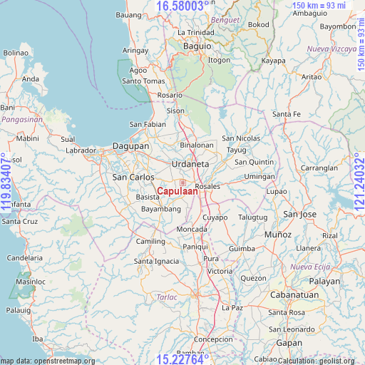
Capulaan GPS coordinates[2]
15° 54' 17.892" North, 120° 32' 13.884" East
| Map corner | latitude | longitude |
|---|---|---|
| Upper-left | 16.58003°, | 119.83407° |
| Center: | 15.90497°, | 120.53719° |
| Lower-right: | 15.22764°, | 121.24032° |
| Map W x H: | 150.4×150.4 km | = 93.5×93.5mi |
| max Lat: | 20.78733° ⇑13.8% North |
| Capulaan: | 15.90497° |
| min Lat: | ⇓86.2% South 4.65442° |
| min Long | Capulaan | max Long |
| 117.04868° | 120.53719° | 126.58417° |
| W 10.1%⇐ | ⇒89.9% E |
Elevation
Elevation of Capulaan is 41 m = 135 ft, and this is 46.9 m = 154 ft below average elevation for this country.
| Max E: |
2262 m = 7421 ft | 35.3% |
| Avg. | 87.9 m = 288 ft | |
| Capulaan | 41 m = 135 ft | |
Min E: |
-2 m = -7 ft | 64.7% |
See also: Philippines elevation on elevation.city.
Geographical zone
Capulaan is located in North Torrid zone (between Equator and Tropic of Cancer). Distance of this Northern Tropic circle is 837.5 km =520.4 mi to North.| Distance of | km | miles | from Capulaan |
|---|---|---|---|
| North Pole | 8238.6 | 5119.2 | to North |
| Arctic Circle | 5632.7 | 3500 | to North |
| Tropic Cancer | 837.5 | 520.4 | to North |
| Equator | 1768.5 | 1098.9 | to South |


Nearby cities:
15 places around Capulaan: (largest is in red/bold)
• Alcala
6.6 km =4.1 mi,  192°
192°
• Bacag
5.6 km =3.5 mi,  59°
59°
• Bacundao Weste
6.6 km =4.1 mi,  280°
280°
• Barangobong
3.2 km =2 mi,  158°
158°
• Canan Norte
6.4 km =4 mi,  274°
274°
• Caramutan
8 km =5 mi,  77°
77°
• Carmen
7 km =4.3 mi,  107°
107°
• Lunec
7.5 km =4.7 mi,  316°
316°
• Olea
6.6 km =4.1 mi,  224°
224°
• Pindangan Centro
5.2 km =3.2 mi, 162°
• Puelay
4.4 km =2.7 mi,  117°
117°
• Sanlibo
1.9 km =1.2 mi,  46°
46°
• Tombod
4.4 km =2.7 mi, 47°
• Unzad
1.6 km =1 mi,  7°
7°
• Villasis
5.5 km =3.4 mi,  93°
93°
Sources, notices
• [Note1] Compared only with cities in Philippines existing in our database
• [Src1] Map data: © OpenStreetMap contributors (CC-BY-SA)
• [Src2] Other city data from geonames.org with taken over terms of usage.
• [Src3] Geographical zone / Annual Mean Temperature by Robert A. Rohde @ Wikipedia
