Lepa geodata
Lepa (Ilocos) is a populated place; located in Philippines in Asia/Manila (GMT+8) time zone. With population of 8,877 people, there are 702 cities with bigger population in this country. Compared to other cities in Philippines, 85.9% of cities are located further ↓South; 92.2% of cities are located further →East and 53.1% of cities have higher elevation than Lepa. Note1


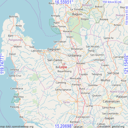
Lepa GPS coordinates[2]
15° 53' 3.768" North, 120° 27' 3.204" East
| Map corner | latitude | longitude |
|---|---|---|
| Upper-left | 16.55951°, | 119.74777° |
| Center: | 15.88438°, | 120.45089° |
| Lower-right: | 15.20698°, | 121.15402° |
| Map W x H: | 150.4×150.4 km | = 93.5×93.5mi |
| max Lat: | 20.78733° ⇑14.1% North |
| Lepa: | 15.88438° |
| min Lat: | ⇓85.9% South 4.65442° |
| min Long | Lepa | max Long |
| 117.04868° | 120.45089° | 126.58417° |
| W 7.8%⇐ | ⇒92.2% E |
Elevation
Elevation of Lepa is 21 m = 69 ft, and this is 66.9 m = 219 ft below average elevation for this country.
| Max E: |
2262 m = 7421 ft | 53.1% |
| Avg. | 87.9 m = 288 ft | |
| Lepa | 21 m = 69 ft | |
Min E: |
-2 m = -7 ft | 46.9% |
See also: Philippines elevation on elevation.city.
Geographical zone
Lepa is located in North Torrid zone (between Equator and Tropic of Cancer). Distance of this Northern Tropic circle is 839.7 km =521.8 mi to North.| Distance of | km | miles | from Lepa |
|---|---|---|---|
| North Pole | 8240.9 | 5120.7 | to North |
| Arctic Circle | 5635 | 3501.4 | to North |
| Tropic Cancer | 839.7 | 521.8 | to North |
| Equator | 1766.2 | 1097.5 | to South |


Nearby cities:
15 places around Lepa: (largest is in red/bold)
• Anambongan
7 km =4.3 mi,  253°
253°
• Bacundao Weste
4.4 km =2.7 mi,  38°
38°
• Basista
6.7 km =4.2 mi,  238°
238°
• Bolaoit
5.7 km =3.5 mi,  337°
337°
• Botao
5.1 km =3.2 mi,  314°
314°
• Canan Norte
4 km =2.5 mi,  45°
45°
• Don Pedro
2.2 km =1.4 mi,  272°
272°
• Dumpay
6.6 km =4.1 mi, 268°
• Loqueb Este
6.7 km =4.2 mi,  355°
355°
• Malasiqui
5.6 km =3.5 mi,  315°
315°
• Nalsian Norte
4.4 km =2.7 mi,  180°
180°
• Olea
5.2 km =3.2 mi,  118°
118°
• Polong Norte
3.8 km =2.4 mi,  303°
303°
• Talospatang
3.8 km =2.4 mi, 344°
• Tococ East
7.1 km =4.4 mi,  201°
201°
Sources, notices
• [Note1] Compared only with cities in Philippines existing in our database
• [Src1] Map data: © OpenStreetMap contributors (CC-BY-SA)
• [Src2] Other city data from geonames.org with taken over terms of usage.
• [Src3] Geographical zone / Annual Mean Temperature by Robert A. Rohde @ Wikipedia
