Monreal geodata
Monreal (Bicol) is a seat of a third-order administrative division; located in Philippines in Asia/Manila (GMT+8) time zone. With population of 4,759 people, there are 1391 cities with bigger population in this country. Compared to other cities in Philippines, 55.8% of cities are located further ↓South; 64.9% of cities are located further ←West and 85.4% of cities have higher elevation than Monreal. Note1


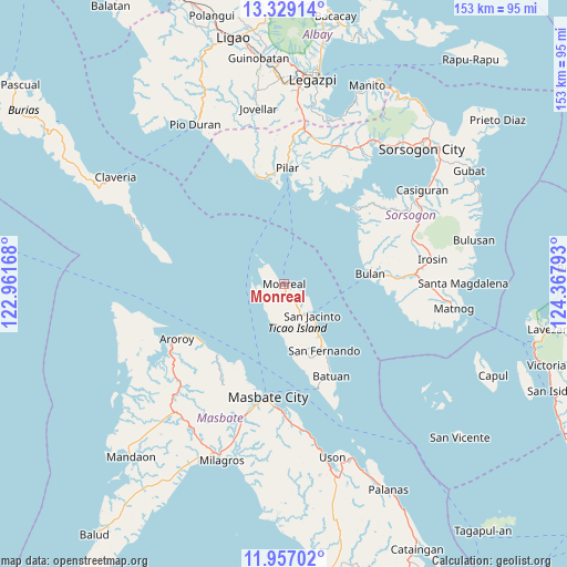
Monreal GPS coordinates[2]
12° 38' 38.4" North, 123° 39' 53.28" East
| Map corner | latitude | longitude |
|---|---|---|
| Upper-left | 13.32914°, | 122.96168° |
| Center: | 12.644°, | 123.6648° |
| Lower-right: | 11.95702°, | 124.36793° |
| Map W x H: | 152.6×152.6 km | = 94.8×94.8mi |
| max Lat: | 20.78733° ⇑44.2% North |
| Monreal: | 12.644° |
| min Lat: | ⇓55.8% South 4.65442° |
| min Long | Monreal | max Long |
| 117.04868° | 123.6648° | 126.58417° |
| W 64.9%⇐ | ⇒35.1% E |
Elevation
Elevation of Monreal is 8 m = 26 ft, and this is 79.9 m = 262 ft below average elevation for this country.
| Max E: |
2262 m = 7421 ft | 85.4% |
| Avg. | 87.9 m = 288 ft | |
| Monreal | 8 m = 26 ft | |
Min E: |
-2 m = -7 ft | 14.6% |
See also: Philippines elevation on elevation.city.
Geographical zone
Monreal is located in North Torrid zone (between Equator and Tropic of Cancer). Distance of this Northern Tropic circle is 1200 km =745.6 mi to North.| Distance of | km | miles | from Monreal |
|---|---|---|---|
| North Pole | 8601.2 | 5344.5 | to North |
| Arctic Circle | 5995.3 | 3725.3 | to North |
| Tropic Cancer | 1200 | 745.6 | to North |
| Equator | 1405.9 | 873.6 | to South |


Nearby cities:
15 places around Monreal: (largest is in red/bold)
• Aguada
26.5 km =16.5 mi,  43°
43°
• Bagahanlad
7.2 km =4.5 mi,  176°
176°
• Baleno
26.2 km =16.3 mi,  223°
223°
• Bulan
23 km =14.3 mi,  82°
82°
• Bulo
28 km =17.4 mi,  202°
202°
• Butag
29.2 km =18.1 mi,  93°
93°
• Caditaan
26.9 km =16.7 mi,  48°
48°
• Luna
12.9 km =8 mi,  144°
144°
• Magallanes
27.8 km =17.3 mi, 42°
• Ogod
29 km =18 mi,  349°
349°
• San Fernando
20.8 km =12.9 mi,  149°
149°
• San Francisco
27.7 km =17.2 mi,  71°
71°
• San Jacinto
11.3 km =7 mi, 138°
• San Rafael
27.5 km =17.1 mi,  3°
3°
• Utabi
26.5 km =16.5 mi, 90°
Sources, notices
• [Note1] Compared only with cities in Philippines existing in our database
• [Src1] Map data: © OpenStreetMap contributors (CC-BY-SA)
• [Src2] Other city data from geonames.org with taken over terms of usage.
• [Src3] Geographical zone / Annual Mean Temperature by Robert A. Rohde @ Wikipedia
