Santa Rita Aplaya geodata
Santa Rita Aplaya (Calabarzon) is a section of populated place; located in Philippines in Asia/Manila (GMT+8) time zone. With population of 9,737 people, there are 628 cities with bigger population in this country. Compared to other cities in Philippines, 65.2% of cities are located further ↓South; 75.4% of cities are located further →East and 80.7% of cities have higher elevation than Santa Rita Aplaya. Note1
Administrative division(s):
- Level 1: Calabarzon
- Level 2: Province of Batangas
- Level 3: Batangas City


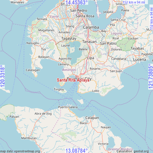
Santa Rita Aplaya GPS coordinates[2]
13° 46' 18.228" North, 121° 2' 5.712" East
| Map corner | latitude | longitude |
|---|---|---|
| Upper-left | 14.45363°, | 120.3318° |
| Center: | 13.77173°, | 121.03492° |
| Lower-right: | 13.08784°, | 121.73805° |
| Map W x H: | 151.9×151.9 km | = 94.4×94.4mi |
| max Lat: | 20.78733° ⇑34.8% North |
| Santa Rita Aplaya: | 13.77173° |
| min Lat: | ⇓65.2% South 4.65442° |
| min Long | Santa Rita Apla | max Long |
| 117.04868° | 121.03492° | 126.58417° |
| W 24.6%⇐ | ⇒75.4% E |
Elevation
Elevation of Santa Rita Aplaya is 9 m = 30 ft, and this is 78.9 m = 259 ft below average elevation for this country.
| Max E: |
2262 m = 7421 ft | 80.7% |
| Avg. | 87.9 m = 288 ft | |
| Santa Rita Aplaya | 9 m = 30 ft | |
Min E: |
-2 m = -7 ft | 19.3% |
See also: Philippines elevation on elevation.city.
Geographical zone
Santa Rita Aplaya is located in North Torrid zone (between Equator and Tropic of Cancer). Distance of this Northern Tropic circle is 1074.6 km =667.7 mi to North.| Distance of | km | miles | from Santa Rita Aplaya |
|---|---|---|---|
| North Pole | 8475.8 | 5266.6 | to North |
| Arctic Circle | 5869.9 | 3647.4 | to North |
| Tropic Cancer | 1074.6 | 667.7 | to North |
| Equator | 1531.3 | 951.5 | to South |


Nearby cities:
15 places around Santa Rita Aplaya: (largest is in red/bold)
• Alitagtag
10.8 km =6.7 mi,  342°
342°
• Batangas
3 km =1.9 mi,  123°
123°
• Bauan
3.6 km =2.2 mi,  307°
307°
• Bolo
6.1 km =3.8 mi,  289°
289°
• Bukal
9.6 km =6 mi,  41°
41°
• Calumpang
10.1 km =6.3 mi,  320°
320°
• Inicbulan
7.8 km =4.8 mi, 314°
• Mabini
10.4 km =6.5 mi,  258°
258°
• Mozon
10.3 km =6.4 mi,  331°
331°
• Mulauin
10.7 km =6.6 mi,  349°
349°
• San Pascual
4.5 km =2.8 mi, 342°
• Santa Clara
3.4 km =2.1 mi,  126°
126°
• Santo Niño
10.1 km =6.3 mi,  140°
140°
• Sinala
7.5 km =4.7 mi,  300°
300°
• Wawa
4 km =2.5 mi,  151°
151°
Sources, notices
• [Note1] Compared only with cities in Philippines existing in our database
• [Src1] Map data: © OpenStreetMap contributors (CC-BY-SA)
• [Src2] Other city data from geonames.org with taken over terms of usage.
• [Src3] Geographical zone / Annual Mean Temperature by Robert A. Rohde @ Wikipedia
