Angatel geodata
Angatel (Ilocos) is a populated place; located in Philippines in Asia/Manila (GMT+8) time zone. With population of 2,359 people, there are 3540 cities with bigger population in this country. Compared to other cities in Philippines, 84.9% of cities are located further ↓South; 94.9% of cities are located further →East and 54.5% of cities have higher elevation than Angatel. Note1


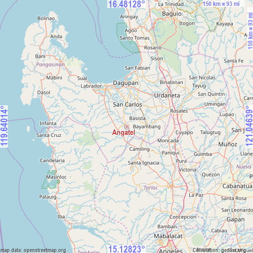
Angatel GPS coordinates[2]
15° 48' 21.204" North, 120° 20' 35.736" East
| Map corner | latitude | longitude |
|---|---|---|
| Upper-left | 16.48128°, | 119.64014° |
| Center: | 15.80589°, | 120.34326° |
| Lower-right: | 15.12823°, | 121.04639° |
| Map W x H: | 150.4×150.4 km | = 93.5×93.5mi |
| max Lat: | 20.78733° ⇑15.1% North |
| Angatel: | 15.80589° |
| min Lat: | ⇓84.9% South 4.65442° |
| min Long | Angatel | max Long |
| 117.04868° | 120.34326° | 126.58417° |
| W 5.1%⇐ | ⇒94.9% E |
Elevation
Elevation of Angatel is 20 m = 66 ft, and this is 67.9 m = 223 ft below average elevation for this country.
| Max E: |
2262 m = 7421 ft | 54.5% |
| Avg. | 87.9 m = 288 ft | |
| Angatel | 20 m = 66 ft | |
Min E: |
-2 m = -7 ft | 45.5% |
See also: Philippines elevation on elevation.city.
Geographical zone
Angatel is located in North Torrid zone (between Equator and Tropic of Cancer). Distance of this Northern Tropic circle is 848.5 km =527.2 mi to North.| Distance of | km | miles | from Angatel |
|---|---|---|---|
| North Pole | 8249.6 | 5126.1 | to North |
| Arctic Circle | 5643.7 | 3506.8 | to North |
| Tropic Cancer | 848.5 | 527.2 | to North |
| Equator | 1757.5 | 1092.1 | to South |


Nearby cities:
15 places around Angatel: (largest is in red/bold)
• Anambongan
8.3 km =5.2 mi,  35°
35°
• Bacnar
9 km =5.6 mi,  0°
0°
• Basista
7.8 km =4.8 mi,  48°
48°
• Bogtong
5.8 km =3.6 mi,  195°
195°
• Dorongan Punta
2.4 km =1.5 mi,  294°
294°
• Libas
8.5 km =5.3 mi,  340°
340°
• Linmansangan
5.7 km =3.5 mi,  297°
297°
• Malibong East
4.9 km =3 mi, 338°
• Mangatarem
5.8 km =3.6 mi,  249°
249°
• Navatat
7 km =4.3 mi, 46°
• Pasibi West
7 km =4.3 mi,  33°
33°
• Real
0.4 km =0.2 mi, 35°
• Tanolong
7.6 km =4.7 mi,  91°
91°
• Tocok
7.7 km =4.8 mi,  216°
216°
• Urbiztondo
2.4 km =1.5 mi,  321°
321°
Sources, notices
• [Note1] Compared only with cities in Philippines existing in our database
• [Src1] Map data: © OpenStreetMap contributors (CC-BY-SA)
• [Src2] Other city data from geonames.org with taken over terms of usage.
• [Src3] Geographical zone / Annual Mean Temperature by Robert A. Rohde @ Wikipedia
