Anambongan geodata
Anambongan (Ilocos) is a populated place; located in Philippines in Asia/Manila (GMT+8) time zone. With population of 2,504 people, there are 3275 cities with bigger population in this country. Compared to other cities in Philippines, 85.7% of cities are located further ↓South; 94.2% of cities are located further →East and 53.1% of cities have higher elevation than Anambongan. Note1


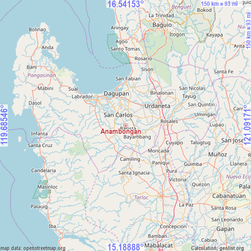
Anambongan GPS coordinates[2]
15° 51' 58.824" North, 120° 23' 18.888" East
| Map corner | latitude | longitude |
|---|---|---|
| Upper-left | 16.54153°, | 119.68546° |
| Center: | 15.86634°, | 120.38858° |
| Lower-right: | 15.18888°, | 121.09171° |
| Map W x H: | 150.4×150.4 km | = 93.5×93.5mi |
| max Lat: | 20.78733° ⇑14.3% North |
| Anambongan: | 15.86634° |
| min Lat: | ⇓85.7% South 4.65442° |
| min Long | Anambongan | max Long |
| 117.04868° | 120.38858° | 126.58417° |
| W 5.8%⇐ | ⇒94.2% E |
Elevation
Elevation of Anambongan is 21 m = 69 ft, and this is 66.9 m = 219 ft below average elevation for this country.
| Max E: |
2262 m = 7421 ft | 53.1% |
| Avg. | 87.9 m = 288 ft | |
| Anambongan | 21 m = 69 ft | |
Min E: |
-2 m = -7 ft | 46.9% |
See also: Philippines elevation on elevation.city.
Geographical zone
Anambongan is located in North Torrid zone (between Equator and Tropic of Cancer). Distance of this Northern Tropic circle is 841.7 km =523 mi to North.| Distance of | km | miles | from Anambongan |
|---|---|---|---|
| North Pole | 8242.9 | 5121.9 | to North |
| Arctic Circle | 5637 | 3502.7 | to North |
| Tropic Cancer | 841.7 | 523 | to North |
| Equator | 1764.2 | 1096.2 | to South |


Nearby cities:
15 places around Anambongan: (largest is in red/bold)
• Bacnar
5.2 km =3.2 mi,  295°
295°
• Basista
1.8 km =1.1 mi,  148°
148°
• Botao
6.4 km =4 mi,  28°
28°
• Don Pedro
4.9 km =3 mi,  64°
64°
• Dumpay
1.8 km =1.1 mi,  1°
1°
• Lepa
7 km =4.3 mi,  73°
73°
• Malasiqui
6.6 km =4.1 mi,  24°
24°
• Malibong East
7 km =4.3 mi,  251°
251°
• Mapolopolo
2.2 km =1.4 mi,  316°
316°
• Nalsian Norte
7.1 km =4.4 mi,  109°
109°
• Navatat
1.9 km =1.2 mi,  173°
173°
• Pasibi West
1.3 km =0.8 mi,  229°
229°
• Polong Norte
5.4 km =3.4 mi,  40°
40°
• Taloy
6.5 km =4 mi,  7°
7°
• Tococ East
6.1 km =3.8 mi,  138°
138°
Sources, notices
• [Note1] Compared only with cities in Philippines existing in our database
• [Src1] Map data: © OpenStreetMap contributors (CC-BY-SA)
• [Src2] Other city data from geonames.org with taken over terms of usage.
• [Src3] Geographical zone / Annual Mean Temperature by Robert A. Rohde @ Wikipedia
