Bogtong geodata
Bogtong (Ilocos) is a populated place; located in Philippines in Asia/Manila (GMT+8) time zone. With population of 3,999 people, there are 1732 cities with bigger population in this country. Compared to other cities in Philippines, 84.4% of cities are located further ↓South; 95.1% of cities are located further →East and 50.3% of cities have higher elevation than Bogtong. Note1


Bogtong GPS coordinates[2]
15° 45' 19.296" North, 120° 19' 44.364" East
| Map corner | latitude | longitude |
|---|---|---|
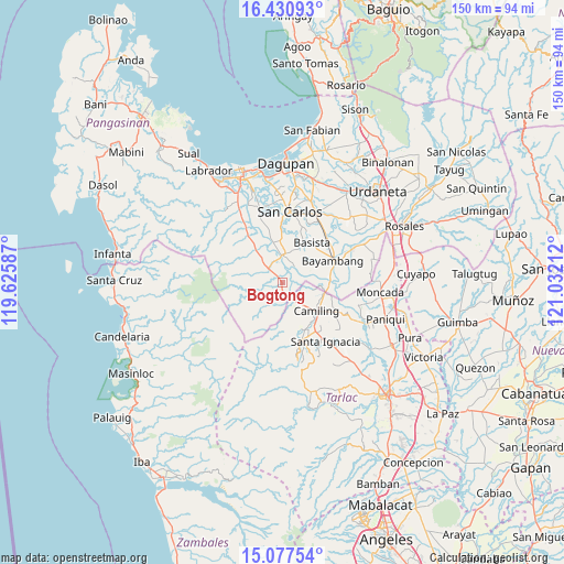
| Upper-left | 16.43093°, | 119.62587° |
| Center: | 15.75536°, | 120.32899° |
| Lower-right: | 15.07754°, | 121.03212° |
| Map W x H: | 150.5×150.5 km | = 93.5×93.5mi |
| max Lat: | 20.78733° ⇑15.6% North |
| Bogtong: | 15.75536° |
| min Lat: | ⇓84.4% South 4.65442° |
| min Long | Bogtong | max Long |
| 117.04868° | 120.32899° | 126.58417° |
| W 4.9%⇐ | ⇒95.1% E |
Elevation
Elevation of Bogtong is 23 m = 75 ft, and this is 64.9 m = 213 ft below average elevation for this country.
| Max E: |
2262 m = 7421 ft | 50.3% |
| Avg. | 87.9 m = 288 ft | |
| Bogtong | 23 m = 75 ft | |
Min E: |
-2 m = -7 ft | 49.7% |
See also: Philippines elevation on elevation.city.
Geographical zone
Bogtong is located in North Torrid zone (between Equator and Tropic of Cancer). Distance of this Northern Tropic circle is 854.1 km =530.7 mi to North.| Distance of | km | miles | from Bogtong |
|---|---|---|---|
| North Pole | 8255.2 | 5129.5 | to North |
| Arctic Circle | 5649.3 | 3510.3 | to North |
| Tropic Cancer | 854.1 | 530.7 | to North |
| Equator | 1751.8 | 1088.5 | to South |


Nearby cities:
15 places around Bogtong: (largest is in red/bold)
• Angatel
5.8 km =3.6 mi,  15°
15°
• Bacabac
11.1 km =6.9 mi,  107°
107°
• Bamban
9 km =5.6 mi,  178°
178°
• Bayaoas
11.1 km =6.9 mi,  321°
321°
• Bilad
11.3 km =7 mi,  100°
100°
• Dorongan Punta
6.6 km =4.1 mi,  354°
354°
• Linmansangan
9 km =5.6 mi,  336°
336°
• Malibong East
10.1 km =6.3 mi,  358°
358°
• Mangatarem
5.3 km =3.3 mi,  312°
312°
• Pogonsili
10.3 km =6.4 mi, 314°
• Real
6.2 km =3.9 mi, 16°
• San Clemente
5.8 km =3.6 mi,  146°
146°
• Tanolong
10.6 km =6.6 mi,  59°
59°
• Tocok
3.2 km =2 mi,  259°
259°
• Urbiztondo
7.5 km =4.7 mi,  0°
0°
Sources, notices
• [Note1] Compared only with cities in Philippines existing in our database
• [Src1] Map data: © OpenStreetMap contributors (CC-BY-SA)
• [Src2] Other city data from geonames.org with taken over terms of usage.
• [Src3] Geographical zone / Annual Mean Temperature by Robert A. Rohde @ Wikipedia
