Navatat geodata
Navatat (Ilocos) is a populated place; located in Philippines in Asia/Manila (GMT+8) time zone. With population of 2,493 people, there are 3307 cities with bigger population in this country. Compared to other cities in Philippines, 85.5% of cities are located further ↓South; 94.1% of cities are located further →East and 59.2% of cities have higher elevation than Navatat. Note1


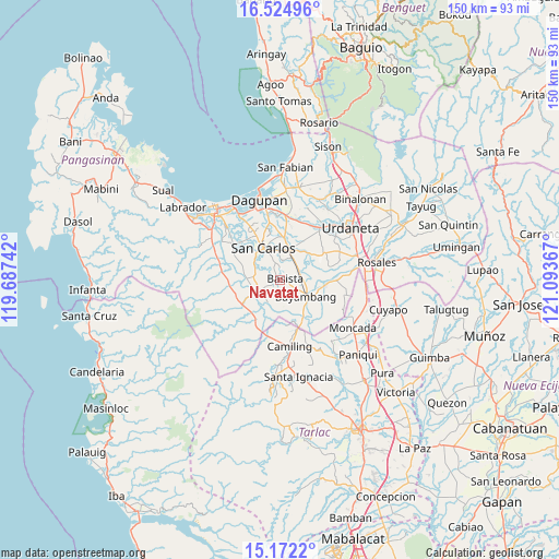
Navatat GPS coordinates[2]
15° 50' 58.956" North, 120° 23' 25.944" East
| Map corner | latitude | longitude |
|---|---|---|
| Upper-left | 16.52496°, | 119.68742° |
| Center: | 15.84971°, | 120.39054° |
| Lower-right: | 15.1722°, | 121.09367° |
| Map W x H: | 150.4×150.4 km | = 93.5×93.5mi |
| max Lat: | 20.78733° ⇑14.5% North |
| Navatat: | 15.84971° |
| min Lat: | ⇓85.5% South 4.65442° |
| min Long | Navatat | max Long |
| 117.04868° | 120.39054° | 126.58417° |
| W 5.9%⇐ | ⇒94.1% E |
Elevation
Elevation of Navatat is 17 m = 56 ft, and this is 70.9 m = 233 ft below average elevation for this country.
| Max E: |
2262 m = 7421 ft | 59.2% |
| Avg. | 87.9 m = 288 ft | |
| Navatat | 17 m = 56 ft | |
Min E: |
-2 m = -7 ft | 40.8% |
See also: Philippines elevation on elevation.city.
Geographical zone
Navatat is located in North Torrid zone (between Equator and Tropic of Cancer). Distance of this Northern Tropic circle is 843.6 km =524.2 mi to North.| Distance of | km | miles | from Navatat |
|---|---|---|---|
| North Pole | 8244.7 | 5123 | to North |
| Arctic Circle | 5638.9 | 3503.8 | to North |
| Tropic Cancer | 843.6 | 524.2 | to North |
| Equator | 1762.3 | 1095 | to South |


Nearby cities:
15 places around Navatat: (largest is in red/bold)
• Anambongan
1.9 km =1.2 mi,  353°
353°
• Angatel
7 km =4.3 mi,  226°
226°
• Bacnar
6.4 km =4 mi,  309°
309°
• Basista
0.8 km =0.5 mi,  68°
68°
• Bical Norte
6.2 km =3.9 mi,  129°
129°
• Don Pedro
5.8 km =3.6 mi,  47°
47°
• Dumpay
3.7 km =2.3 mi,  357°
357°
• Malibong East
6.8 km =4.2 mi,  267°
267°
• Mapolopolo
3.9 km =2.4 mi,  333°
333°
• Nalsian Norte
6.5 km =4 mi,  94°
94°
• Pasibi West
1.6 km =1 mi, 309°
• Polong Norte
6.8 km =4.2 mi,  29°
29°
• Real
6.6 km =4.1 mi, 226°
• Tanolong
5.7 km =3.5 mi,  153°
153°
• Tococ East
4.7 km =2.9 mi, 125°
Sources, notices
• [Note1] Compared only with cities in Philippines existing in our database
• [Src1] Map data: © OpenStreetMap contributors (CC-BY-SA)
• [Src2] Other city data from geonames.org with taken over terms of usage.
• [Src3] Geographical zone / Annual Mean Temperature by Robert A. Rohde @ Wikipedia
