Barra geodata
Barra (Northern Mindanao) is a populated place; located in Philippines in Asia/Manila (GMT+8) time zone. With population of 12,442 people, there are 508 cities with bigger population in this country. Compared to other cities in Philippines, 78.7% of cities are located further ↑North; 80.9% of cities are located further ←West and 99.6% of cities have higher elevation than Barra. Note1
Administrative division(s):
- Level 1: Northern Mindanao
- Level 2: Province of Misamis Oriental
- Level 3: Opol


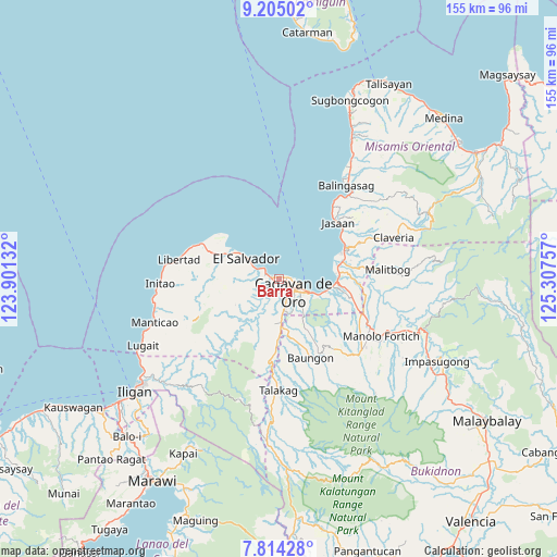
Barra GPS coordinates[2]
8° 30' 37.008" North, 124° 36' 15.984" East
| Map corner | latitude | longitude |
|---|---|---|
| Upper-left | 9.20502°, | 123.90132° |
| Center: | 8.51028°, | 124.60444° |
| Lower-right: | 7.81428°, | 125.30757° |
| Map W x H: | 154.6×154.6 km | = 96.1×96.1mi |
| max Lat: | 20.78733° ⇑78.7% North |
| Barra: | 8.51028° |
| min Lat: | ⇓21.3% South 4.65442° |
| min Long | Barra | max Long |
| 117.04868° | 124.60444° | 126.58417° |
| W 80.9%⇐ | ⇒19.1% E |
Elevation
Elevation of Barra is 1 m = 3 ft, and this is 86.9 m = 285 ft below average elevation for this country.
| Max E: |
2262 m = 7421 ft | 99.6% |
| Avg. | 87.9 m = 288 ft | |
| Barra | 1 m = 3 ft | |
Min E: |
-2 m = -7 ft | 0.4% |
See also: Philippines elevation on elevation.city.
Geographical zone
Barra is located in North Torrid zone (between Equator and Tropic of Cancer). Distance of Equator is 946.3 km =588 mi to South.| Distance of | km | miles | from Barra |
|---|---|---|---|
| North Pole | 9060.8 | 5630.1 | to North |
| Arctic Circle | 6454.9 | 4010.9 | to North |
| Tropic Cancer | 1659.7 | 1031.3 | to North |
| Equator | 946.3 | 588 | to South |


Nearby cities:
15 places around Barra: (largest is in red/bold)
• Agusan
14.8 km =9.2 mi,  98°
98°
• Alubijid
16 km =9.9 mi,  295°
295°
• Baikingon
7 km =4.3 mi,  232°
232°
• Bolo Bolo
9.8 km =6.1 mi, 303°
• Bugo
17 km =10.6 mi,  90°
90°
• Cagayan de Oro
5.6 km =3.5 mi,  123°
123°
• El Salvador
10.8 km =6.7 mi, 303°
• Igpit
2 km =1.2 mi,  271°
271°
• Liboran
18 km =11.2 mi,  164°
164°
• Lumbia
12.8 km =8 mi,  185°
185°
• Molugan
5.5 km =3.4 mi, 303°
• Opol
3.9 km =2.4 mi,  288°
288°
• Tagoloan
16.8 km =10.4 mi,  78°
78°
• Taypano
16.3 km =10.1 mi,  197°
197°
• Taytay
7.9 km =4.9 mi, 295°
Sources, notices
• [Note1] Compared only with cities in Philippines existing in our database
• [Src1] Map data: © OpenStreetMap contributors (CC-BY-SA)
• [Src2] Other city data from geonames.org with taken over terms of usage.
• [Src3] Geographical zone / Annual Mean Temperature by Robert A. Rohde @ Wikipedia
