Alibunan geodata
Alibunan (Western Visayas) is a populated place; located in Philippines in Asia/Manila (GMT+8) time zone. With population of 2,798 people, there are 2793 cities with bigger population in this country. Compared to other cities in Philippines, 55.2% of cities are located further ↑North; 55.5% of cities are located further →East and 82.8% of cities have lower elevation than Alibunan. Note1


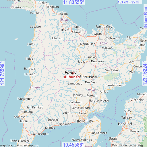
Alibunan GPS coordinates[2]
11° 8' 47.472" North, 122° 27' 32.796" East
| Map corner | latitude | longitude |
|---|---|---|
| Upper-left | 11.83555°, | 121.75599° |
| Center: | 11.14652°, | 122.45911° |
| Lower-right: | 10.45586°, | 123.16224° |
| Map W x H: | 153.4×153.4 km | = 95.3×95.3mi |
| max Lat: | 20.78733° ⇑55.2% North |
| Alibunan: | 11.14652° |
| min Lat: | ⇓44.8% South 4.65442° |
| min Long | Alibunan | max Long |
| 117.04868° | 122.45911° | 126.58417° |
| W 44.5%⇐ | ⇒55.5% E |
Elevation
Elevation of Alibunan is 114 m = 374 ft, and this is 26.1 m = 86 ft above average elevation for this country.
| Max E: |
2262 m = 7421 ft | 17.2% |
| Alibunan | 114 m 374 ft | |
| Avg. | 87.9 m = 288 ft | |
Min E: |
-2 m = -7 ft | 82.8% |
See also: Philippines elevation on elevation.city.
Geographical zone
Alibunan is located in North Torrid zone (between Equator and Tropic of Cancer). Distance of Equator is 1239.4 km =770.1 mi to South.| Distance of | km | miles | from Alibunan |
|---|---|---|---|
| North Pole | 8767.7 | 5448 | to North |
| Arctic Circle | 6161.8 | 3828.8 | to North |
| Tropic Cancer | 1366.5 | 849.1 | to North |
| Equator | 1239.4 | 770.1 | to South |


Nearby cities:
15 places around Alibunan: (largest is in red/bold)
• Badiangan
16.3 km =10.1 mi,  163°
163°
• Badlan
6.7 km =4.2 mi,  94°
94°
• Binabaan
15.7 km =9.8 mi,  154°
154°
• Bingawan
15.2 km =9.4 mi,  50°
50°
• Calinog
12.2 km =7.6 mi,  105°
105°
• Candelaria
17.3 km =10.7 mi,  23°
23°
• Da-an Sur
13.4 km =8.3 mi,  341°
341°
• Dueñas
19.2 km =11.9 mi,  117°
117°
• Duran
19.3 km =12 mi, 48°
• Jayubó
13.5 km =8.4 mi,  217°
217°
• Lambunao
10.3 km =6.4 mi,  169°
169°
• Maribong
9.6 km =6 mi, 122°
• Quinagaringan
14.3 km =8.9 mi,  100°
100°
• San Miguel
11.8 km =7.3 mi, 50°
• Tapas
15.3 km =9.5 mi,  33°
33°
Sources, notices
• [Note1] Compared only with cities in Philippines existing in our database
• [Src1] Map data: © OpenStreetMap contributors (CC-BY-SA)
• [Src2] Other city data from geonames.org with taken over terms of usage.
• [Src3] Geographical zone / Annual Mean Temperature by Robert A. Rohde @ Wikipedia
