Alfonso geodata
Alfonso (Calabarzon) is a seat of a third-order administrative division; located in Philippines in Asia/Manila (GMT+8) time zone. With population of 9,446 people, there are 653 cities with bigger population in this country. Compared to other cities in Philippines, 71% of cities are located further ↓South; 80.9% of cities are located further →East and 95% of cities have lower elevation than Alfonso. Note1


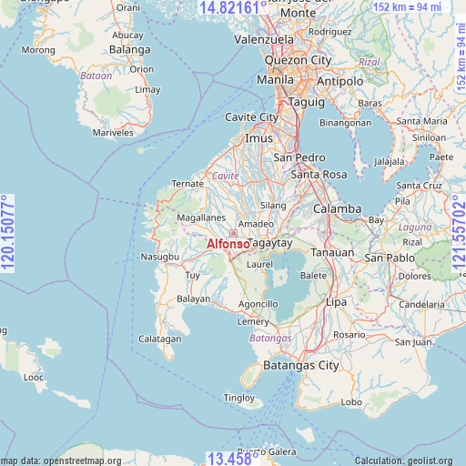
Alfonso GPS coordinates[2]
14° 8' 26.988" North, 120° 51' 14.004" East
| Map corner | latitude | longitude |
|---|---|---|
| Upper-left | 14.82161°, | 120.15077° |
| Center: | 14.14083°, | 120.85389° |
| Lower-right: | 13.458°, | 121.55702° |
| Map W x H: | 151.6×151.6 km | = 94.2×94.2mi |
| max Lat: | 20.78733° ⇑29% North |
| Alfonso: | 14.14083° |
| min Lat: | ⇓71% South 4.65442° |
| min Long | Alfonso | max Long |
| 117.04868° | 120.85389° | 126.58417° |
| W 19.1%⇐ | ⇒80.9% E |
Elevation
Elevation of Alfonso is 413 m = 1355 ft, and this is 325.1 m = 1067 ft above average elevation for this country.
| Max E: |
2262 m = 7421 ft | 5% |
| Alfonso | 413 m 1355 ft | |
| Avg. | 87.9 m = 288 ft | |
Min E: |
-2 m = -7 ft | 95% |
See also: Philippines elevation on elevation.city.
Geographical zone
Alfonso is located in North Torrid zone (between Equator and Tropic of Cancer). Distance of this Northern Tropic circle is 1033.6 km =642.2 mi to North.| Distance of | km | miles | from Alfonso |
|---|---|---|---|
| North Pole | 8434.7 | 5241.1 | to North |
| Arctic Circle | 5828.9 | 3621.9 | to North |
| Tropic Cancer | 1033.6 | 642.2 | to North |
| Equator | 1572.3 | 977 | to South |


Nearby cities:
15 places around Alfonso: (largest is in red/bold)
• Aga
7.4 km =4.6 mi,  228°
228°
• Amadeo
8.2 km =5.1 mi,  66°
66°
• Anuling
4.5 km =2.8 mi,  114°
114°
• Banaba
8.4 km =5.2 mi,  357°
357°
• Batas
7.7 km =4.8 mi,  328°
328°
• General Emilio Aguinaldo
7.9 km =4.9 mi,  307°
307°
• Guyam Malaki
1.5 km =0.9 mi,  30°
30°
• Indang
6.5 km =4 mi,  22°
22°
• Kaytitinga
4.6 km =2.9 mi,  215°
215°
• Luksuhin
5.7 km =3.5 mi,  149°
149°
• Mangas
2.9 km =1.8 mi, 151°
• Matagbak
2.4 km =1.5 mi,  241°
241°
• Mendez-Nuñez
5.8 km =3.6 mi,  103°
103°
• Pangil
8.9 km =5.5 mi,  40°
40°
• Taywanak Ilaya
2 km =1.2 mi,  336°
336°
Sources, notices
• [Note1] Compared only with cities in Philippines existing in our database
• [Src1] Map data: © OpenStreetMap contributors (CC-BY-SA)
• [Src2] Other city data from geonames.org with taken over terms of usage.
• [Src3] Geographical zone / Annual Mean Temperature by Robert A. Rohde @ Wikipedia
