Guyam Malaki geodata
Guyam Malaki (Calabarzon) is a populated place; located in Philippines in Asia/Manila (GMT+8) time zone. With population of 3,050 people, there are 2474 cities with bigger population in this country. Compared to other cities in Philippines, 71.1% of cities are located further ↓South; 80.7% of cities are located further →East and 94.6% of cities have lower elevation than Guyam Malaki. Note1


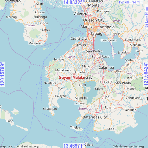
Guyam Malaki GPS coordinates[2]
14° 9' 9" North, 120° 51' 39.996" East
| Map corner | latitude | longitude |
|---|---|---|
| Upper-left | 14.83325°, | 120.15799° |
| Center: | 14.1525°, | 120.86111° |
| Lower-right: | 13.46971°, | 121.56424° |
| Map W x H: | 151.6×151.6 km | = 94.2×94.2mi |
| max Lat: | 20.78733° ⇑28.9% North |
| Guyam Malaki: | 14.1525° |
| min Lat: | ⇓71.1% South 4.65442° |
| min Long | Guyam Malaki | max Long |
| 117.04868° | 120.86111° | 126.58417° |
| W 19.3%⇐ | ⇒80.7% E |
Elevation
Elevation of Guyam Malaki is 395 m = 1296 ft, and this is 307.1 m = 1008 ft above average elevation for this country.
| Max E: |
2262 m = 7421 ft | 5.4% |
| Guyam Malaki | 395 m 1296 ft | |
| Avg. | 87.9 m = 288 ft | |
Min E: |
-2 m = -7 ft | 94.6% |
See also: Philippines elevation on elevation.city.
Geographical zone
Guyam Malaki is located in North Torrid zone (between Equator and Tropic of Cancer). Distance of this Northern Tropic circle is 1032.3 km =641.4 mi to North.| Distance of | km | miles | from Guyam Malaki |
|---|---|---|---|
| North Pole | 8433.5 | 5240.3 | to North |
| Arctic Circle | 5827.6 | 3621.1 | to North |
| Tropic Cancer | 1032.3 | 641.4 | to North |
| Equator | 1573.6 | 977.8 | to South |


Nearby cities:
15 places around Guyam Malaki: (largest is in red/bold)
• Aga
8.9 km =5.5 mi,  225°
225°
• Alfonso
1.5 km =0.9 mi,  210°
210°
• Amadeo
7 km =4.3 mi,  73°
73°
• Anuling
4.6 km =2.9 mi,  133°
133°
• Banaba
7.2 km =4.5 mi,  350°
350°
• Batas
7.1 km =4.4 mi,  317°
317°
• General Emilio Aguinaldo
7.9 km =4.9 mi,  296°
296°
• Indang
5.1 km =3.2 mi,  19°
19°
• Kaytitinga
6.1 km =3.8 mi, 214°
• Luksuhin
6.6 km =4.1 mi,  161°
161°
• Mangas
3.9 km =2.4 mi,  171°
171°
• Matagbak
3.7 km =2.3 mi, 229°
• Mendez-Nuñez
5.5 km =3.4 mi,  118°
118°
• Pangil
7.4 km =4.6 mi,  43°
43°
• Taywanak Ilaya
1.7 km =1.1 mi,  289°
289°
Sources, notices
• [Note1] Compared only with cities in Philippines existing in our database
• [Src1] Map data: © OpenStreetMap contributors (CC-BY-SA)
• [Src2] Other city data from geonames.org with taken over terms of usage.
• [Src3] Geographical zone / Annual Mean Temperature by Robert A. Rohde @ Wikipedia
