Anuling geodata
Anuling (Calabarzon) is a populated place; located in Philippines in Asia/Manila (GMT+8) time zone. With population of 3,905 people, there are 1785 cities with bigger population in this country. Compared to other cities in Philippines, 70.8% of cities are located further ↓South; 79.7% of cities are located further →East and 96.2% of cities have lower elevation than Anuling. Note1
Administrative division(s):
- Level 1: Calabarzon
- Level 2: Province of Cavite
- Level 3: Mendez (Mendez-Nuñez)


Anuling GPS coordinates[2]
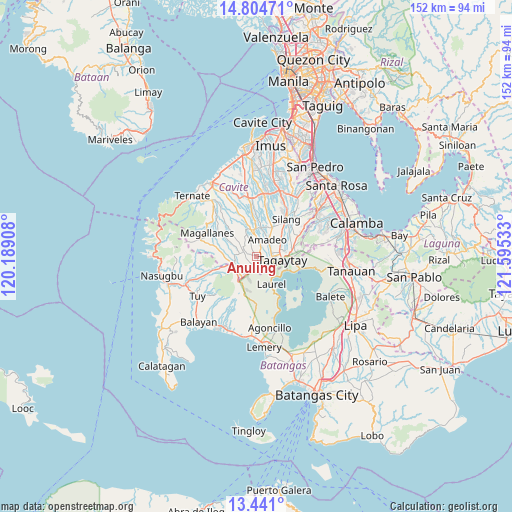
14° 7' 25.968" North, 120° 53' 31.92" East
| Map corner | latitude | longitude |
|---|---|---|
| Upper-left | 14.80471°, | 120.18908° |
| Center: | 14.12388°, | 120.8922° |
| Lower-right: | 13.441°, | 121.59533° |
| Map W x H: | 151.6×151.6 km | = 94.2×94.2mi |
| max Lat: | 20.78733° ⇑29.2% North |
| Anuling: | 14.12388° |
| min Lat: | ⇓70.8% South 4.65442° |
| min Long | Anuling | max Long |
| 117.04868° | 120.8922° | 126.58417° |
| W 20.3%⇐ | ⇒79.7% E |
Elevation
Elevation of Anuling is 522 m = 1713 ft, and this is 434.1 m = 1424 ft above average elevation for this country.
| Max E: |
2262 m = 7421 ft | 3.8% |
| Anuling | 522 m 1713 ft | |
| Avg. | 87.9 m = 288 ft | |
Min E: |
-2 m = -7 ft | 96.2% |
See also: Philippines elevation on elevation.city.
Geographical zone
Anuling is located in North Torrid zone (between Equator and Tropic of Cancer). Distance of this Northern Tropic circle is 1035.5 km =643.4 mi to North.| Distance of | km | miles | from Anuling |
|---|---|---|---|
| North Pole | 8436.6 | 5242.3 | to North |
| Arctic Circle | 5830.7 | 3623 | to North |
| Tropic Cancer | 1035.5 | 643.4 | to North |
| Equator | 1570.4 | 975.8 | to South |


Nearby cities:
15 places around Anuling: (largest is in red/bold)
• Alfonso
4.5 km =2.8 mi,  294°
294°
• Amadeo
6.2 km =3.9 mi,  33°
33°
• Guyam Malaki
4.6 km =2.9 mi,  313°
313°
• Indang
8.1 km =5 mi,  348°
348°
• Kaytitinga
7 km =4.3 mi,  254°
254°
• Laurel
8.2 km =5.1 mi,  158°
158°
• Luksuhin
3.3 km =2.1 mi,  202°
202°
• Malabag
8.6 km =5.3 mi,  66°
66°
• Mangas
2.8 km =1.7 mi,  255°
255°
• Matagbak
6.2 km =3.9 mi,  276°
276°
• Mendez-Nuñez
1.6 km =1 mi, 70°
• Pangil
8.7 km =5.4 mi,  11°
11°
• Patuto
8.1 km =5 mi,  95°
95°
• Tagaytay
5.5 km =3.4 mi,  125°
125°
• Taywanak Ilaya
6.2 km =3.9 mi, 307°
Sources, notices
• [Note1] Compared only with cities in Philippines existing in our database
• [Src1] Map data: © OpenStreetMap contributors (CC-BY-SA)
• [Src2] Other city data from geonames.org with taken over terms of usage.
• [Src3] Geographical zone / Annual Mean Temperature by Robert A. Rohde @ Wikipedia
