Khairpur Mir’s geodata
Khairpur Mir’s (Sindh) is a seat of a second-order administrative division; located in Pakistan in Asia/Karachi (GMT+5) time zone. With population of 124,602 people, there are 55 cities with bigger population in this country. Compared to other cities in Pakistan, 77.7% of cities are located further ↑North; 73.4% of cities are located further →East and 76.3% of cities have higher elevation than Khairpur Mir’s. Note1


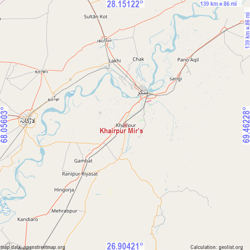
Khairpur Mir’s GPS coordinates[2]
27° 31' 46.128" North, 68° 45' 32.94" East
| Map corner | latitude | longitude |
|---|---|---|
| Upper-left | 28.15122°, | 68.05603° |
| Center: | 27.52948°, | 68.75915° |
| Lower-right: | 26.90421°, | 69.46228° |
| Map W x H: | 138.7×138.7 km | = 86.2×86.2mi |
| max Lat: | 36.32162° ⇑77.7% North |
| Khairpur Mir’s: | 27.52948° |
| min Lat: | ⇓22.3% South 24.14422° |
| min Long | Khairpur Mir’ | max Long |
| 61.74573° | 68.75915° | 75.63372° |
| W 26.6%⇐ | ⇒73.4% E |
Elevation
Elevation of Khairpur Mir’s is 60 m = 197 ft, and this is 285 m = 935 ft below average elevation for this country.
| Max E: |
2732 m = 8963 ft | 76.3% |
| Avg. | 345 m = 1132 ft | |
| Khairpur Mir’s | 60 m = 197 ft | |
Min E: |
3 m = 10 ft | 23.7% |
See also: Khairpur Mir’s elevation on elevation.city.
Geographical zone
Khairpur Mir’s is located in North temperate zone (between Tropic of Cancer and the Arctic Circle). Distance of this Northern Tropic circle is 455.1 km =282.8 mi to South.| Distance of | km | miles | from Khairpur Mir’s |
|---|---|---|---|
| North Pole | 6946.1 | 4316.1 | to North |
| Arctic Circle | 4340.2 | 2696.9 | to North |
| Tropic Cancer | 455.1 | 282.8 | to South |
| Equator | 3061 | 1902 | to South |


Nearby cities:
15 places around Khairpur Mir’s: (largest is in red/bold)
• Bagarji
25 km =15.5 mi,  359°
359°
• Bozdar Wada
40.4 km =25.1 mi,  197°
197°
• Chak
37.3 km =23.2 mi,  11°
11°
• Gambat
30.7 km =19.1 mi,  229°
229°
• Garhiyasin
48.4 km =30.1 mi,  329°
329°
• Kot Diji
21.5 km =13.4 mi,  193°
193°
• Lakhi
36 km =22.4 mi,  350°
350°
• Madeji
39.2 km =24.4 mi,  309°
309°
• Naudero
42.1 km =26.2 mi,  291°
291°
• Pir Jo Goth
15.5 km =9.6 mi,  296°
296°
• Ranipur
36.7 km =22.8 mi,  222°
222°
• Rohri
22.5 km =14 mi,  36°
36°
• Setharja Old
45.4 km =28.2 mi, 219°
• Sobhodero
43.6 km =27.1 mi,  235°
235°
• Sukkur
21.7 km =13.5 mi,  26°
26°
Sources, notices
• [Note1] Compared only with cities in Pakistan existing in our database
• [Src1] Map data: © OpenStreetMap contributors (CC-BY-SA)
• [Src2] Other city data from geonames.org with taken over terms of usage.
• [Src3] Geographical zone / Annual Mean Temperature by Robert A. Rohde @ Wikipedia
