Garhiyasin geodata
Garhiyasin (Sindh) is a populated place; located in Pakistan in Asia/Karachi (GMT+5) time zone. With population of 14,810 people, there are 315 cities with bigger population in this country. Compared to other cities in Pakistan, 73.8% of cities are located further ↑North; 78.3% of cities are located further →East and 76.3% of cities have higher elevation than Garhiyasin. Note1


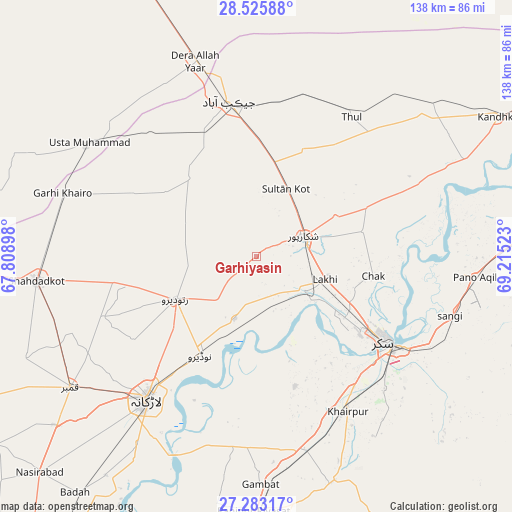
Garhiyasin GPS coordinates[2]
27° 54' 22.716" North, 68° 30' 43.56" East
| Map corner | latitude | longitude |
|---|---|---|
| Upper-left | 28.52588°, | 67.80898° |
| Center: | 27.90631°, | 68.5121° |
| Lower-right: | 27.28317°, | 69.21523° |
| Map W x H: | 138.2×138.2 km | = 85.9×85.9mi |
| max Lat: | 36.32162° ⇑73.8% North |
| Garhiyasin: | 27.90631° |
| min Lat: | ⇓26.2% South 24.14422° |
| min Long | Garhiyasin | max Long |
| 61.74573° | 68.5121° | 75.63372° |
| W 21.7%⇐ | ⇒78.3% E |
Elevation
Elevation of Garhiyasin is 60 m = 197 ft, and this is 285 m = 935 ft below average elevation for this country.
| Max E: |
2732 m = 8963 ft | 76.3% |
| Avg. | 345 m = 1132 ft | |
| Garhiyasin | 60 m = 197 ft | |
Min E: |
3 m = 10 ft | 23.7% |
See also: Pakistan elevation on elevation.city.
Geographical zone
Garhiyasin is located in North temperate zone (between Tropic of Cancer and the Arctic Circle). Distance of this Northern Tropic circle is 497 km =308.8 mi to South.| Distance of | km | miles | from Garhiyasin |
|---|---|---|---|
| North Pole | 6904.2 | 4290.1 | to North |
| Arctic Circle | 4298.3 | 2670.8 | to North |
| Tropic Cancer | 497 | 308.8 | to South |
| Equator | 3102.9 | 1928.1 | to South |


Nearby cities:
15 places around Garhiyasin: (largest is in red/bold)
• Bagarji
29.6 km =18.4 mi,  124°
124°
• Chak
32.1 km =19.9 mi,  99°
99°
• Jacobabad
42.4 km =26.3 mi,  350°
350°
• Khairpur Mir’s
48.4 km =30.1 mi,  149°
149°
• Lakhi
19.5 km =12.1 mi,  109°
109°
• Madeji
18 km =11.2 mi,  199°
199°
• Miro Khan
44.4 km =27.6 mi,  248°
248°
• Naudero
30.5 km =19 mi,  209°
209°
• Pir Jo Goth
36.5 km =22.7 mi,  163°
163°
• Ratodero
24.8 km =15.4 mi,  242°
242°
• Rohri
44.6 km =27.7 mi, 122°
• Rustam
29.4 km =18.3 mi,  76°
76°
• Shikarpur
13.5 km =8.4 mi,  66°
66°
• Sukkur
40.9 km =25.4 mi, 123°
• Thul
45.2 km =28.1 mi,  34°
34°
Sources, notices
• [Note1] Compared only with cities in Pakistan existing in our database
• [Src1] Map data: © OpenStreetMap contributors (CC-BY-SA)
• [Src2] Other city data from geonames.org with taken over terms of usage.
• [Src3] Geographical zone / Annual Mean Temperature by Robert A. Rohde @ Wikipedia
