Gambat geodata
Gambat (Sindh) is a populated place; located in Pakistan in Asia/Karachi (GMT+5) time zone. With population of 34,005 people, there are 187 cities with bigger population in this country. Compared to other cities in Pakistan, 78.8% of cities are located further ↑North; 78.1% of cities are located further →East and 80.4% of cities have higher elevation than Gambat. Note1


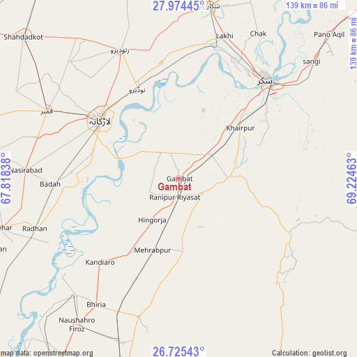
Gambat GPS coordinates[2]
27° 21' 6.12" North, 68° 31' 17.4" East
| Map corner | latitude | longitude |
|---|---|---|
| Upper-left | 27.97445°, | 67.81838° |
| Center: | 27.3517°, | 68.5215° |
| Lower-right: | 26.72543°, | 69.22463° |
| Map W x H: | 138.9×138.9 km | = 86.3×86.3mi |
| max Lat: | 36.32162° ⇑78.8% North |
| Gambat: | 27.3517° |
| min Lat: | ⇓21.2% South 24.14422° |
| min Long | Gambat | max Long |
| 61.74573° | 68.5215° | 75.63372° |
| W 21.9%⇐ | ⇒78.1% E |
Elevation
Elevation of Gambat is 53 m = 174 ft, and this is 292 m = 958 ft below average elevation for this country.
| Max E: |
2732 m = 8963 ft | 80.4% |
| Avg. | 345 m = 1132 ft | |
| Gambat | 53 m = 174 ft | |
Min E: |
3 m = 10 ft | 19.6% |
See also: Pakistan elevation on elevation.city.
Geographical zone
Gambat is located in North temperate zone (between Tropic of Cancer and the Arctic Circle). Distance of this Northern Tropic circle is 435.3 km =270.5 mi to South.| Distance of | km | miles | from Gambat |
|---|---|---|---|
| North Pole | 6965.8 | 4328.3 | to North |
| Arctic Circle | 4360 | 2709.2 | to North |
| Tropic Cancer | 435.3 | 270.5 | to South |
| Equator | 3041.2 | 1889.7 | to South |


Nearby cities:
15 places around Gambat: (largest is in red/bold)
• Bozdar Wada
21.9 km =13.6 mi,  148°
148°
• Dokri
42 km =26.1 mi,  273°
273°
• Goth Garelo
45 km =28 mi,  281°
281°
• Hingorja
18.8 km =11.7 mi,  213°
213°
• Kandiaro
44.8 km =27.8 mi,  223°
223°
• Khairpur Mir’s
30.7 km =19.1 mi,  49°
49°
• Kot Diji
18.5 km =11.5 mi,  93°
93°
• Larkana
38.3 km =23.8 mi,  307°
307°
• Madeji
45.2 km =28.1 mi,  351°
351°
• Naudero
38.5 km =23.9 mi,  335°
335°
• New Bādāh
48.4 km =30.1 mi, 268°
• Pir Jo Goth
28.4 km =17.6 mi,  19°
19°
• Ranipur
7.3 km =4.5 mi,  191°
191°
• Setharja Old
16.3 km =10.1 mi,  198°
198°
• Sobhodero
13.3 km =8.3 mi,  246°
246°
Sources, notices
• [Note1] Compared only with cities in Pakistan existing in our database
• [Src1] Map data: © OpenStreetMap contributors (CC-BY-SA)
• [Src2] Other city data from geonames.org with taken over terms of usage.
• [Src3] Geographical zone / Annual Mean Temperature by Robert A. Rohde @ Wikipedia
