Sukkur geodata
Sukkur (Sindh) is a seat of a second-order administrative division; located in Pakistan in Asia/Karachi (GMT+5) time zone. With population of 417,767 people, there are 17 cities with bigger population in this country. Compared to other cities in Pakistan, 76.3% of cities are located further ↑North; 71.1% of cities are located further →East and 72.2% of cities have higher elevation than Sukkur. Note1


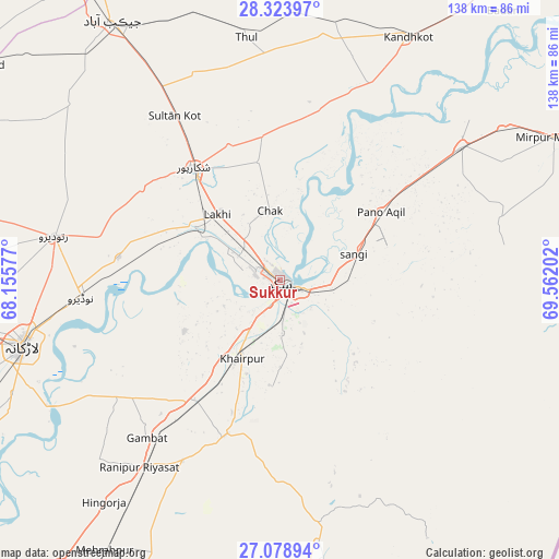
Sukkur GPS coordinates[2]
27° 42' 11.628" North, 68° 51' 32.004" East
| Map corner | latitude | longitude |
|---|---|---|
| Upper-left | 28.32397°, | 68.15577° |
| Center: | 27.70323°, | 68.85889° |
| Lower-right: | 27.07894°, | 69.56202° |
| Map W x H: | 138.4×138.4 km | = 86×86mi |
| max Lat: | 36.32162° ⇑76.3% North |
| Sukkur: | 27.70323° |
| min Lat: | ⇓23.7% South 24.14422° |
| min Long | Sukkur | max Long |
| 61.74573° | 68.85889° | 75.63372° |
| W 28.9%⇐ | ⇒71.1% E |
Elevation
Elevation of Sukkur is 72 m = 236 ft, and this is 273 m = 896 ft below average elevation for this country.
| Max E: |
2732 m = 8963 ft | 72.2% |
| Avg. | 345 m = 1132 ft | |
| Sukkur | 72 m = 236 ft | |
Min E: |
3 m = 10 ft | 27.8% |
See also: Sukkur elevation on elevation.city.
Geographical zone
Sukkur is located in North temperate zone (between Tropic of Cancer and the Arctic Circle). Distance of this Northern Tropic circle is 474.4 km =294.8 mi to South.| Distance of | km | miles | from Sukkur |
|---|---|---|---|
| North Pole | 6926.8 | 4304.1 | to North |
| Arctic Circle | 4320.9 | 2684.9 | to North |
| Tropic Cancer | 474.4 | 294.8 | to South |
| Equator | 3080.3 | 1914 | to South |


Nearby cities:
15 places around Sukkur: (largest is in red/bold)
• Adilpur
52.2 km =32.4 mi,  60°
60°
• Bagarji
11.4 km =7.1 mi,  299°
299°
• Chak
17.4 km =10.8 mi,  351°
351°
• Gambat
51.3 km =31.9 mi,  220°
220°
• Garhiyasin
40.9 km =25.4 mi, 303°
• Khairpur Mir’s
21.7 km =13.5 mi,  206°
206°
• Kot Diji
42.9 km =26.7 mi,  200°
200°
• Lakhi
22.5 km =14 mi,  315°
315°
• Madeji
40.5 km =25.2 mi,  277°
277°
• Naudero
49.2 km =30.6 mi,  265°
265°
• Pano Aqil
30.1 km =18.7 mi, 55°
• Pir Jo Goth
26.7 km =16.6 mi,  242°
242°
• Rohri
3.8 km =2.4 mi,  109°
109°
• Rustam
29.8 km =18.5 mi, 349°
• Shikarpur
35.5 km =22.1 mi, 322°
Sources, notices
• [Note1] Compared only with cities in Pakistan existing in our database
• [Src1] Map data: © OpenStreetMap contributors (CC-BY-SA)
• [Src2] Other city data from geonames.org with taken over terms of usage.
• [Src3] Geographical zone / Annual Mean Temperature by Robert A. Rohde @ Wikipedia
