Naudero geodata
Naudero (Sindh) is a populated place; located in Pakistan in Asia/Karachi (GMT+5) time zone. With population of 33,455 people, there are 190 cities with bigger population in this country. Compared to other cities in Pakistan, 76.7% of cities are located further ↑North; 81.3% of cities are located further →East and 78.1% of cities have higher elevation than Naudero. Note1


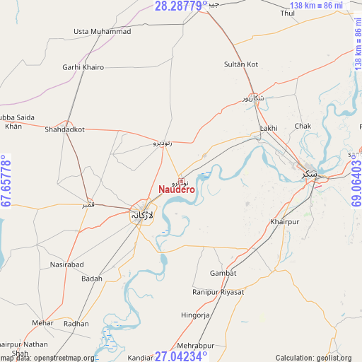
Naudero GPS coordinates[2]
27° 40' 0.624" North, 68° 21' 39.24" East
| Map corner | latitude | longitude |
|---|---|---|
| Upper-left | 28.28779°, | 67.65778° |
| Center: | 27.66684°, | 68.3609° |
| Lower-right: | 27.04234°, | 69.06403° |
| Map W x H: | 138.5×138.5 km | = 86.1×86.1mi |
| max Lat: | 36.32162° ⇑76.7% North |
| Naudero: | 27.66684° |
| min Lat: | ⇓23.3% South 24.14422° |
| min Long | Naudero | max Long |
| 61.74573° | 68.3609° | 75.63372° |
| W 18.7%⇐ | ⇒81.3% E |
Elevation
Elevation of Naudero is 57 m = 187 ft, and this is 288 m = 945 ft below average elevation for this country.
| Max E: |
2732 m = 8963 ft | 78.1% |
| Avg. | 345 m = 1132 ft | |
| Naudero | 57 m = 187 ft | |
Min E: |
3 m = 10 ft | 21.9% |
See also: Pakistan elevation on elevation.city.
Geographical zone
Naudero is located in North temperate zone (between Tropic of Cancer and the Arctic Circle). Distance of this Northern Tropic circle is 470.3 km =292.2 mi to South.| Distance of | km | miles | from Naudero |
|---|---|---|---|
| North Pole | 6930.8 | 4306.6 | to North |
| Arctic Circle | 4324.9 | 2687.4 | to North |
| Tropic Cancer | 470.3 | 292.2 | to South |
| Equator | 3076.3 | 1911.5 | to South |


Nearby cities:
15 places around Naudero: (largest is in red/bold)
• Bagarji
40.3 km =25 mi,  76°
76°
• Dokri
41.7 km =25.9 mi,  218°
218°
• Gambat
38.5 km =23.9 mi,  155°
155°
• Garhiyasin
30.5 km =19 mi,  29°
29°
• Goth Garelo
38.1 km =23.7 mi,  227°
227°
• Kambar
36.6 km =22.7 mi,  256°
256°
• Khairpur Mir’s
42.1 km =26.2 mi,  111°
111°
• Lakhi
39 km =24.2 mi,  58°
58°
• Larkana
18.9 km =11.7 mi, 230°
• Madeji
13.1 km =8.1 mi,  42°
42°
• Miro Khan
28.4 km =17.6 mi,  291°
291°
• Pir Jo Goth
26.7 km =16.6 mi, 108°
• Ratodero
16.6 km =10.3 mi,  334°
334°
• Shikarpur
42.1 km =26.2 mi, 40°
• Sobhodero
40.4 km =25.1 mi,  174°
174°
Sources, notices
• [Note1] Compared only with cities in Pakistan existing in our database
• [Src1] Map data: © OpenStreetMap contributors (CC-BY-SA)
• [Src2] Other city data from geonames.org with taken over terms of usage.
• [Src3] Geographical zone / Annual Mean Temperature by Robert A. Rohde @ Wikipedia
