Utmanzai geodata
Utmanzai (Khyber Pakhtunkhwa) is a populated place; located in Pakistan in Asia/Karachi (GMT+5) time zone. With population of 29,423 people, there are 211 cities with bigger population in this country. Compared to other cities in Pakistan, 93.2% of cities are located further ↓South; 53.7% of cities are located further ←West and 75.6% of cities have lower elevation than Utmanzai. Note1


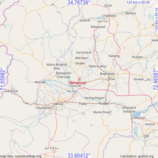
Utmanzai GPS coordinates[2]
34° 11' 15.9" North, 71° 45' 45.864" East
| Map corner | latitude | longitude |
|---|---|---|
| Upper-left | 34.76736°, | 71.05962° |
| Center: | 34.18775°, | 71.76274° |
| Lower-right: | 33.60412°, | 72.46587° |
| Map W x H: | 129.3×129.3 km | = 80.3×80.3mi |
| max Lat: | 36.32162° ⇑6.8% North |
| Utmanzai: | 34.18775° |
| min Lat: | ⇓93.2% South 24.14422° |
| min Long | Utmanzai | max Long |
| 61.74573° | 71.76274° | 75.63372° |
| W 53.7%⇐ | ⇒46.3% E |
Elevation
Elevation of Utmanzai is 304 m = 997 ft, and this is 41 m = 135 ft below average elevation for this country.
| Max E: |
2732 m = 8963 ft | 24.4% |
| Avg. | 345 m = 1132 ft | |
| Utmanzai | 304 m = 997 ft | |
Min E: |
3 m = 10 ft | 75.6% |
See also: Pakistan elevation on elevation.city.
Geographical zone
Utmanzai is located in North temperate zone (between Tropic of Cancer and the Arctic Circle). Distance of this Northern Tropic circle is 1195.4 km =742.8 mi to South.| Distance of | km | miles | from Utmanzai |
|---|---|---|---|
| North Pole | 6205.7 | 3856 | to North |
| Arctic Circle | 3599.9 | 2236.9 | to North |
| Tropic Cancer | 1195.4 | 742.8 | to South |
| Equator | 3801.3 | 2362 | to South |


Nearby cities:
15 places around Utmanzai: (largest is in red/bold)
• Akora
39.2 km =24.4 mi,  121°
121°
• Aman Garh
25.4 km =15.8 mi,  142°
142°
• Ashanagro Koto
45.3 km =28.1 mi,  101°
101°
• Charsadda
4.8 km =3 mi,  204°
204°
• Cherat Cantonement
42.2 km =26.2 mi,  163°
163°
• Malakand
44.7 km =27.8 mi,  20°
20°
• Mardan
26.4 km =16.4 mi,  87°
87°
• Noorabad
20.1 km =12.5 mi,  69°
69°
• Nowshera
27.8 km =17.3 mi,  133°
133°
• Nowshera Cantonment
30.2 km =18.8 mi, 134°
• Pabbi
20 km =12.4 mi,  171°
171°
• Peshawar
26.2 km =16.3 mi,  220°
220°
• Risalpur Cantonment
25.5 km =15.8 mi, 123°
• Shabqadar
19.4 km =12.1 mi,  279°
279°
• Tangi
16.2 km =10.1 mi,  321°
321°
Sources, notices
• [Note1] Compared only with cities in Pakistan existing in our database
• [Src1] Map data: © OpenStreetMap contributors (CC-BY-SA)
• [Src2] Other city data from geonames.org with taken over terms of usage.
• [Src3] Geographical zone / Annual Mean Temperature by Robert A. Rohde @ Wikipedia
