Pabbi geodata
Pabbi (Khyber Pakhtunkhwa) is a populated place; located in Pakistan in Asia/Karachi (GMT+5) time zone. With population of 37,307 people, there are 166 cities with bigger population in this country. Compared to other cities in Pakistan, 90.1% of cities are located further ↓South; 54.2% of cities are located further ←West and 74.9% of cities have lower elevation than Pabbi. Note1


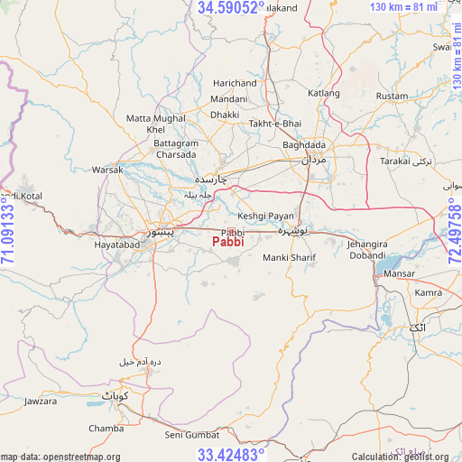
Pabbi GPS coordinates[2]
34° 0' 34.848" North, 71° 47' 40.02" East
| Map corner | latitude | longitude |
|---|---|---|
| Upper-left | 34.59052°, | 71.09133° |
| Center: | 34.00968°, | 71.79445° |
| Lower-right: | 33.42483°, | 72.49758° |
| Map W x H: | 129.6×129.6 km | = 80.5×80.5mi |
| max Lat: | 36.32162° ⇑9.9% North |
| Pabbi: | 34.00968° |
| min Lat: | ⇓90.1% South 24.14422° |
| min Long | Pabbi | max Long |
| 61.74573° | 71.79445° | 75.63372° |
| W 54.2%⇐ | ⇒45.8% E |
Elevation
Elevation of Pabbi is 299 m = 981 ft, and this is 46 m = 151 ft below average elevation for this country.
| Max E: |
2732 m = 8963 ft | 25.1% |
| Avg. | 345 m = 1132 ft | |
| Pabbi | 299 m = 981 ft | |
Min E: |
3 m = 10 ft | 74.9% |
See also: Pakistan elevation on elevation.city.
Geographical zone
Pabbi is located in North temperate zone (between Tropic of Cancer and the Arctic Circle). Distance of this Northern Tropic circle is 1175.6 km =730.5 mi to South.| Distance of | km | miles | from Pabbi |
|---|---|---|---|
| North Pole | 6225.5 | 3868.3 | to North |
| Arctic Circle | 3619.7 | 2249.2 | to North |
| Tropic Cancer | 1175.6 | 730.5 | to South |
| Equator | 3781.5 | 2349.7 | to South |


Nearby cities:
15 places around Pabbi: (largest is in red/bold)
• Akora
30.5 km =19 mi,  91°
91°
• Aman Garh
12.5 km =7.8 mi, 91°
• Ashanagro Koto
42.9 km =26.7 mi,  75°
75°
• Charsadda
16.2 km =10.1 mi,  342°
342°
• Cherat Cantonement
22.6 km =14 mi,  156°
156°
• Kohat
57.3 km =35.6 mi,  213°
213°
• Mardan
31.5 km =19.6 mi,  48°
48°
• Noorabad
31.3 km =19.4 mi,  30°
30°
• Nowshera
17.2 km =10.7 mi, 87°
• Nowshera Cantonment
18.8 km =11.7 mi, 93°
• Peshawar
19.9 km =12.4 mi,  269°
269°
• Risalpur Cantonment
19.1 km =11.9 mi,  72°
72°
• Shabqadar
31.8 km =19.8 mi,  316°
316°
• Tangi
34.9 km =21.7 mi, 338°
• Utmanzai
20 km =12.4 mi,  351°
351°
Sources, notices
• [Note1] Compared only with cities in Pakistan existing in our database
• [Src1] Map data: © OpenStreetMap contributors (CC-BY-SA)
• [Src2] Other city data from geonames.org with taken over terms of usage.
• [Src3] Geographical zone / Annual Mean Temperature by Robert A. Rohde @ Wikipedia
