Malakand geodata
Malakand (Khyber Pakhtunkhwa) is a seat of a second-order administrative division; located in Pakistan in Asia/Karachi (GMT+5) time zone. In our database, there are 416 cities with bigger population. Compared to other cities in Pakistan, 95.5% of cities are located further ↓South; 56% of cities are located further ←West and 86.5% of cities have lower elevation than Malakand. Note1


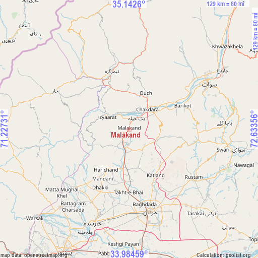
Malakand GPS coordinates[2]
34° 33' 56.196" North, 71° 55' 49.548" East
| Map corner | latitude | longitude |
|---|---|---|
| Upper-left | 35.1426°, | 71.22731° |
| Center: | 34.56561°, | 71.93043° |
| Lower-right: | 33.98459°, | 72.63356° |
| Map W x H: | 128.8×128.8 km | = 80×80mi |
| max Lat: | 36.32162° ⇑4.5% North |
| Malakand: | 34.56561° |
| min Lat: | ⇓95.5% South 24.14422° |
| min Long | Malakand | max Long |
| 61.74573° | 71.93043° | 75.63372° |
| W 56%⇐ | ⇒44% E |
Elevation
Elevation of Malakand is 844 m = 2769 ft, and this is 499 m = 1637 ft above average elevation for this country.
| Max E: |
2732 m = 8963 ft | 13.5% |
| Malakand | 844 m 2769 ft | |
| Avg. | 345 m = 1132 ft | |
Min E: |
3 m = 10 ft | 86.5% |
See also: Pakistan elevation on elevation.city.
Geographical zone
Malakand is located in North temperate zone (between Tropic of Cancer and the Arctic Circle). Distance of this Northern Tropic circle is 1237.4 km =768.9 mi to South.| Distance of | km | miles | from Malakand |
|---|---|---|---|
| North Pole | 6163.7 | 3829.9 | to North |
| Arctic Circle | 3557.8 | 2210.7 | to North |
| Tropic Cancer | 1237.4 | 768.9 | to South |
| Equator | 3843.3 | 2388.1 | to South |


Nearby cities:
15 places around Malakand: (largest is in red/bold)
• Ashanagro Koto
58.5 km =36.4 mi,  150°
150°
• Bat Khela
7 km =4.3 mi,  33°
33°
• Charsadda
49.6 km =30.8 mi,  200°
200°
• Daggar
51.1 km =31.8 mi,  96°
96°
• Kakad Wari Dir Upper
49.8 km =30.9 mi,  15°
15°
• Mardan
42.3 km =26.3 mi,  165°
165°
• Mingora
46.1 km =28.6 mi,  58°
58°
• Noorabad
35 km =21.7 mi, 174°
• Nowshera
61.3 km =38.1 mi,  175°
175°
• Risalpur Cantonment
56.5 km =35.1 mi, 174°
• Saidu Sharif
43.8 km =27.2 mi, 62°
• Shabqadar
52 km =32.3 mi,  221°
221°
• Tangi
38.9 km =24.2 mi, 220°
• Timargara
30.1 km =18.7 mi,  344°
344°
• Utmanzai
44.7 km =27.8 mi, 200°
Sources, notices
• [Note1] Compared only with cities in Pakistan existing in our database
• [Src1] Map data: © OpenStreetMap contributors (CC-BY-SA)
• [Src2] Other city data from geonames.org with taken over terms of usage.
• [Src3] Geographical zone / Annual Mean Temperature by Robert A. Rohde @ Wikipedia
