Mardan geodata
Mardan (Khyber Pakhtunkhwa) is a seat of a second-order administrative division; located in Pakistan in Asia/Karachi (GMT+5) time zone. With population of 300,424 people, there are 23 cities with bigger population in this country. Compared to other cities in Pakistan, 93.5% of cities are located further ↓South; 58% of cities are located further ←West and 76.3% of cities have lower elevation than Mardan. Note1


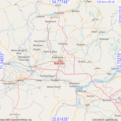
Mardan GPS coordinates[2]
34° 11' 52.584" North, 72° 2' 58.74" East
| Map corner | latitude | longitude |
|---|---|---|
| Upper-left | 34.77748°, | 71.34653° |
| Center: | 34.19794°, | 72.04965° |
| Lower-right: | 33.61438°, | 72.75278° |
| Map W x H: | 129.3×129.3 km | = 80.3×80.3mi |
| max Lat: | 36.32162° ⇑6.5% North |
| Mardan: | 34.19794° |
| min Lat: | ⇓93.5% South 24.14422° |
| min Long | Mardan | max Long |
| 61.74573° | 72.04965° | 75.63372° |
| W 58%⇐ | ⇒42% E |
Elevation
Elevation of Mardan is 311 m = 1020 ft, and this is 34 m = 112 ft below average elevation for this country.
| Max E: |
2732 m = 8963 ft | 23.7% |
| Avg. | 345 m = 1132 ft | |
| Mardan | 311 m = 1020 ft | |
Min E: |
3 m = 10 ft | 76.3% |
See also: Mardan elevation on elevation.city.
Geographical zone
Mardan is located in North temperate zone (between Tropic of Cancer and the Arctic Circle). Distance of this Northern Tropic circle is 1196.5 km =743.5 mi to South.| Distance of | km | miles | from Mardan |
|---|---|---|---|
| North Pole | 6204.6 | 3855.4 | to North |
| Arctic Circle | 3598.7 | 2236.1 | to North |
| Tropic Cancer | 1196.5 | 743.5 | to South |
| Equator | 3802.5 | 2362.8 | to South |


Nearby cities:
15 places around Mardan: (largest is in red/bold)
• Akora
22.7 km =14.1 mi,  162°
162°
• Aman Garh
24 km =14.9 mi,  207°
207°
• Ashanagro Koto
20.6 km =12.8 mi,  119°
119°
• Charsadda
29 km =18 mi,  258°
258°
• Cherat Cantonement
44.1 km =27.4 mi,  199°
199°
• Malakand
42.3 km =26.3 mi,  345°
345°
• Noorabad
9.7 km =6 mi,  308°
308°
• Nowshera
21.2 km =13.2 mi, 197°
• Nowshera Cantonment
22.7 km =14.1 mi,  192°
192°
• Pabbi
31.5 km =19.6 mi,  228°
228°
• Risalpur Cantonment
16.2 km =10.1 mi, 198°
• Swabi
39.6 km =24.6 mi,  102°
102°
• Tangi
38.3 km =23.8 mi,  287°
287°
• Utmanzai
26.4 km =16.4 mi,  267°
267°
• Zaida
41.4 km =25.7 mi,  111°
111°
Sources, notices
• [Note1] Compared only with cities in Pakistan existing in our database
• [Src1] Map data: © OpenStreetMap contributors (CC-BY-SA)
• [Src2] Other city data from geonames.org with taken over terms of usage.
• [Src3] Geographical zone / Annual Mean Temperature by Robert A. Rohde @ Wikipedia
