Cherat Cantonement geodata
Cherat Cantonement (Khyber Pakhtunkhwa) is a populated place; located in Pakistan in Asia/Karachi (GMT+5) time zone. With population of 2,986 people, there are 392 cities with bigger population in this country. Compared to other cities in Pakistan, 87.6% of cities are located further ↓South; 55.1% of cities are located further ←West and 92.8% of cities have lower elevation than Cherat Cantonement. Note1


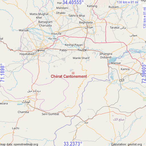
Cherat Cantonement GPS coordinates[2]
33° 49' 24.312" North, 71° 53' 34.512" East
| Map corner | latitude | longitude |
|---|---|---|
| Upper-left | 34.40555°, | 71.1898° |
| Center: | 33.82342°, | 71.89292° |
| Lower-right: | 33.2373°, | 72.59605° |
| Map W x H: | 129.9×129.9 km | = 80.7×80.7mi |
| max Lat: | 36.32162° ⇑12.4% North |
| Cherat Cantonement: | 33.82342° |
| min Lat: | ⇓87.6% South 24.14422° |
| min Long | Cherat Cantonem | max Long |
| 61.74573° | 71.89292° | 75.63372° |
| W 55.1%⇐ | ⇒44.9% E |
Elevation
Elevation of Cherat Cantonement is 1336 m = 4383 ft, and this is 991 m = 3251 ft above average elevation for this country.
| Max E: |
2732 m = 8963 ft | 7.2% |
| Cherat Cantonement | 1336 m 4383 ft | |
| Avg. | 345 m = 1132 ft | |
Min E: |
3 m = 10 ft | 92.8% |
See also: Pakistan elevation on elevation.city.
Geographical zone
Cherat Cantonement is located in North temperate zone (between Tropic of Cancer and the Arctic Circle). Distance of this Northern Tropic circle is 1154.9 km =717.6 mi to South.| Distance of | km | miles | from Cherat Cantonement |
|---|---|---|---|
| North Pole | 6246.3 | 3881.3 | to North |
| Arctic Circle | 3640.4 | 2262 | to North |
| Tropic Cancer | 1154.9 | 717.6 | to South |
| Equator | 3760.8 | 2336.9 | to South |


Nearby cities:
15 places around Cherat Cantonement: (largest is in red/bold)
• Akora
29.3 km =18.2 mi,  47°
47°
• Aman Garh
20.6 km =12.8 mi,  9°
9°
• Ashanagro Koto
45.3 km =28.1 mi, 45°
• Attock City
43.6 km =27.1 mi,  98°
98°
• Charsadda
38.7 km =24 mi,  338°
338°
• Jand
44.9 km =27.9 mi,  164°
164°
• Kohat
49 km =30.4 mi,  236°
236°
• Mardan
44.1 km =27.4 mi,  19°
19°
• Noorabad
48.1 km =29.9 mi, 8°
• Nowshera
22.9 km =14.2 mi, 20°
• Nowshera Cantonment
21.7 km =13.5 mi,  26°
26°
• Pabbi
22.6 km =14 mi, 336°
• Peshawar
35.5 km =22.1 mi,  305°
305°
• Risalpur Cantonment
27.9 km =17.3 mi, 19°
• Utmanzai
42.2 km =26.2 mi, 343°
Sources, notices
• [Note1] Compared only with cities in Pakistan existing in our database
• [Src1] Map data: © OpenStreetMap contributors (CC-BY-SA)
• [Src2] Other city data from geonames.org with taken over terms of usage.
• [Src3] Geographical zone / Annual Mean Temperature by Robert A. Rohde @ Wikipedia
