Uthal geodata
Uthal (Balochistan) is a seat of a second-order administrative division; located in Pakistan in Asia/Karachi (GMT+5) time zone. With population of 16,483 people, there are 294 cities with bigger population in this country. Compared to other cities in Pakistan, 88.9% of cities are located further ↑North; 96.6% of cities are located further →East and 85.8% of cities have higher elevation than Uthal. Note1


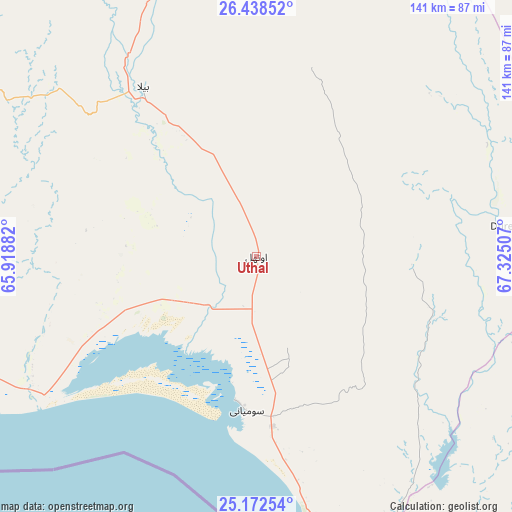
Uthal GPS coordinates[2]
25° 48' 25.992" North, 66° 37' 18.984" East
| Map corner | latitude | longitude |
|---|---|---|
| Upper-left | 26.43852°, | 65.91882° |
| Center: | 25.80722°, | 66.62194° |
| Lower-right: | 25.17254°, | 67.32507° |
| Map W x H: | 140.8×140.8 km | = 87.5×87.5mi |
| max Lat: | 36.32162° ⇑88.9% North |
| Uthal: | 25.80722° |
| min Lat: | ⇓11.1% South 24.14422° |
| min Long | Uthal | max Long |
| 61.74573° | 66.62194° | 75.63372° |
| W 3.4%⇐ | ⇒96.6% E |
Elevation
Elevation of Uthal is 43 m = 141 ft, and this is 302 m = 991 ft below average elevation for this country.
| Max E: |
2732 m = 8963 ft | 85.8% |
| Avg. | 345 m = 1132 ft | |
| Uthal | 43 m = 141 ft | |
Min E: |
3 m = 10 ft | 14.2% |
See also: Pakistan elevation on elevation.city.
Geographical zone
Uthal is located in North temperate zone (between Tropic of Cancer and the Arctic Circle). Distance of this Northern Tropic circle is 263.6 km =163.8 mi to South.| Distance of | km | miles | from Uthal |
|---|---|---|---|
| North Pole | 7137.6 | 4435.1 | to North |
| Arctic Circle | 4531.7 | 2815.9 | to North |
| Tropic Cancer | 263.6 | 163.8 | to South |
| Equator | 2869.5 | 1783 | to South |


Nearby cities:
15 places around Uthal: (largest is in red/bold)
• Awaran
156.5 km =97.2 mi,  297°
297°
• Bela
56 km =34.8 mi,  326°
326°
• Bhan
137.9 km =85.7 mi,  52°
52°
• Dadu
154.3 km =95.9 mi, 48°
• Daulatpur
155.2 km =96.4 mi,  60°
60°
• Gadani
77.3 km =48 mi,  171°
171°
• Gharo
153 km =95.1 mi,  140°
140°
• Goth Phulji
159.4 km =99 mi,  41°
41°
• Johi
139.6 km =86.7 mi, 45°
• Karachi
112.2 km =69.7 mi,  159°
159°
• Malir Cantonment
112.5 km =69.9 mi,  148°
148°
• Moro
167.2 km =103.9 mi, 55°
• Nooriabad
137.5 km =85.4 mi,  120°
120°
• Sann
153.8 km =95.6 mi,  80°
80°
• Sehwan
141.5 km =87.9 mi, 60°
Sources, notices
• [Note1] Compared only with cities in Pakistan existing in our database
• [Src1] Map data: © OpenStreetMap contributors (CC-BY-SA)
• [Src2] Other city data from geonames.org with taken over terms of usage.
• [Src3] Geographical zone / Annual Mean Temperature by Robert A. Rohde @ Wikipedia
