Moro geodata
Moro (Sindh) is a populated place; located in Pakistan in Asia/Karachi (GMT+5) time zone. With population of 76,765 people, there are 84 cities with bigger population in this country. Compared to other cities in Pakistan, 84.2% of cities are located further ↑North; 87.8% of cities are located further →East and 85.3% of cities have higher elevation than Moro. Note1


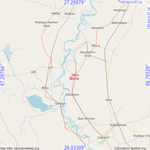
Moro GPS coordinates[2]
26° 39' 47.412" North, 68° 0' 0.576" East
| Map corner | latitude | longitude |
|---|---|---|
| Upper-left | 27.28979°, | 67.29704° |
| Center: | 26.66317°, | 68.00016° |
| Lower-right: | 26.03309°, | 68.70329° |
| Map W x H: | 139.7×139.7 km | = 86.8×86.8mi |
| max Lat: | 36.32162° ⇑84.2% North |
| Moro: | 26.66317° |
| min Lat: | ⇓15.8% South 24.14422° |
| min Long | Moro | max Long |
| 61.74573° | 68.00016° | 75.63372° |
| W 12.2%⇐ | ⇒87.8% E |
Elevation
Elevation of Moro is 44 m = 144 ft, and this is 301 m = 988 ft below average elevation for this country.
| Max E: |
2732 m = 8963 ft | 85.3% |
| Avg. | 345 m = 1132 ft | |
| Moro | 44 m = 144 ft | |
Min E: |
3 m = 10 ft | 14.7% |
See also: Moro elevation on elevation.city.
Geographical zone
Moro is located in North temperate zone (between Tropic of Cancer and the Arctic Circle). Distance of this Northern Tropic circle is 358.7 km =222.9 mi to South.| Distance of | km | miles | from Moro |
|---|---|---|---|
| North Pole | 7042.4 | 4375.9 | to North |
| Arctic Circle | 4436.5 | 2756.7 | to North |
| Tropic Cancer | 358.7 | 222.9 | to South |
| Equator | 2964.7 | 1842.2 | to South |


Nearby cities:
15 places around Moro: (largest is in red/bold)
• Bandhi
31.2 km =19.4 mi,  105°
105°
• Bhan
30.1 km =18.7 mi,  247°
247°
• Bhiria
33.6 km =20.9 mi,  35°
35°
• Dadu
23.4 km =14.5 mi,  288°
288°
• Darya Khan Marri
28.5 km =17.7 mi,  86°
86°
• Daulatpur
18.2 km =11.3 mi,  189°
189°
• Daur
39.2 km =24.4 mi,  126°
126°
• Goth Phulji
39.8 km =24.7 mi,  307°
307°
• Johi
38.5 km =23.9 mi,  274°
274°
• Karaundi
48 km =29.8 mi,  57°
57°
• Naushahro Firoz
23.1 km =14.4 mi,  31°
31°
• Pad Idan
32.3 km =20.1 mi,  67°
67°
• Sehwan
29.9 km =18.6 mi,  207°
207°
• Sīta Road
43.8 km =27.2 mi,  340°
340°
• Tharu Shah
33.2 km =20.6 mi,  20°
20°
Sources, notices
• [Note1] Compared only with cities in Pakistan existing in our database
• [Src1] Map data: © OpenStreetMap contributors (CC-BY-SA)
• [Src2] Other city data from geonames.org with taken over terms of usage.
• [Src3] Geographical zone / Annual Mean Temperature by Robert A. Rohde @ Wikipedia
