Dadu geodata
Dadu (Sindh) is a seat of a second-order administrative division; located in Pakistan in Asia/Karachi (GMT+5) time zone. With population of 139,784 people, there are 46 cities with bigger population in this country. Compared to other cities in Pakistan, 83.5% of cities are located further ↑North; 91.6% of cities are located further →East and 91.6% of cities have higher elevation than Dadu. Note1


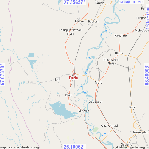
Dadu GPS coordinates[2]
26° 43' 49.188" North, 67° 46' 36.84" East
| Map corner | latitude | longitude |
|---|---|---|
| Upper-left | 27.35657°, | 67.07378° |
| Center: | 26.73033°, | 67.7769° |
| Lower-right: | 26.10062°, | 68.48003° |
| Map W x H: | 139.6×139.6 km | = 86.7×86.7mi |
| max Lat: | 36.32162° ⇑83.5% North |
| Dadu: | 26.73033° |
| min Lat: | ⇓16.5% South 24.14422° |
| min Long | Dadu | max Long |
| 61.74573° | 67.7769° | 75.63372° |
| W 8.4%⇐ | ⇒91.6% E |
Elevation
Elevation of Dadu is 24 m = 79 ft, and this is 321 m = 1053 ft below average elevation for this country.
| Max E: |
2732 m = 8963 ft | 91.6% |
| Avg. | 345 m = 1132 ft | |
| Dadu | 24 m = 79 ft | |
Min E: |
3 m = 10 ft | 8.4% |
See also: Dadu elevation on elevation.city.
Geographical zone
Dadu is located in North temperate zone (between Tropic of Cancer and the Arctic Circle). Distance of this Northern Tropic circle is 366.2 km =227.5 mi to South.| Distance of | km | miles | from Dadu |
|---|---|---|---|
| North Pole | 7034.9 | 4371.3 | to North |
| Arctic Circle | 4429 | 2752.1 | to North |
| Tropic Cancer | 366.2 | 227.5 | to South |
| Equator | 2972.1 | 1846.8 | to South |


Nearby cities:
15 places around Dadu: (largest is in red/bold)
• Bandhi
54.6 km =33.9 mi,  106°
106°
• Bhan
19.9 km =12.4 mi,  196°
196°
• Bhiria
46 km =28.6 mi,  64°
64°
• Darya Khan Marri
51 km =31.7 mi,  96°
96°
• Daulatpur
31.9 km =19.8 mi,  142°
142°
• Goth Phulji
19.2 km =11.9 mi,  330°
330°
• Johi
16.7 km =10.4 mi,  255°
255°
• Khairpur Nathan Shah
40.3 km =25 mi,  354°
354°
• Mehar
50.2 km =31.2 mi,  4°
4°
• Moro
23.4 km =14.5 mi, 108°
• Naushahro Firoz
36.4 km =22.6 mi,  70°
70°
• Pad Idan
52.3 km =32.5 mi,  84°
84°
• Sehwan
35 km =21.7 mi,  166°
166°
• Sīta Road
34.5 km =21.4 mi,  12°
12°
• Tharu Shah
41.2 km =25.6 mi, 55°
Sources, notices
• [Note1] Compared only with cities in Pakistan existing in our database
• [Src1] Map data: © OpenStreetMap contributors (CC-BY-SA)
• [Src2] Other city data from geonames.org with taken over terms of usage.
• [Src3] Geographical zone / Annual Mean Temperature by Robert A. Rohde @ Wikipedia
