Talagang geodata
Talagang (Punjab) is a populated place; located in Pakistan in Asia/Karachi (GMT+5) time zone. With population of 44,960 people, there are 143 cities with bigger population in this country. Compared to other cities in Pakistan, 81.7% of cities are located further ↓South; 63.2% of cities are located further ←West and 80.8% of cities have lower elevation than Talagang. Note1


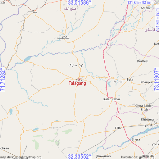
Talagang GPS coordinates[2]
32° 55' 39.576" North, 72° 24' 57.384" East
| Map corner | latitude | longitude |
|---|---|---|
| Upper-left | 33.51586°, | 71.71282° |
| Center: | 32.92766°, | 72.41594° |
| Lower-right: | 32.33552°, | 73.11907° |
| Map W x H: | 131.2×131.2 km | = 81.5×81.5mi |
| max Lat: | 36.32162° ⇑18.3% North |
| Talagang: | 32.92766° |
| min Lat: | ⇓81.7% South 24.14422° |
| min Long | Talagang | max Long |
| 61.74573° | 72.41594° | 75.63372° |
| W 63.2%⇐ | ⇒36.8% E |
Elevation
Elevation of Talagang is 456 m = 1496 ft, and this is 111 m = 364 ft above average elevation for this country.
| Max E: |
2732 m = 8963 ft | 19.2% |
| Talagang | 456 m 1496 ft | |
| Avg. | 345 m = 1132 ft | |
Min E: |
3 m = 10 ft | 80.8% |
See also: Talagang elevation on elevation.city.
Geographical zone
Talagang is located in North temperate zone (between Tropic of Cancer and the Arctic Circle). Distance of this Northern Tropic circle is 1055.3 km =655.7 mi to South.| Distance of | km | miles | from Talagang |
|---|---|---|---|
| North Pole | 6345.8 | 3943.1 | to North |
| Arctic Circle | 3740 | 2323.9 | to North |
| Tropic Cancer | 1055.3 | 655.7 | to South |
| Equator | 3661.2 | 2275 | to South |


Nearby cities:
15 places around Talagang: (largest is in red/bold)
• Bhera
67.7 km =42.1 mi,  137°
137°
• Chakwal
40.9 km =25.4 mi,  89°
89°
• Choa Saidan Shah
58.1 km =36.1 mi,  113°
113°
• Dandot RS
61.2 km =38 mi,  121°
121°
• Dhok Awan
13.7 km =8.5 mi,  132°
132°
• Jand
67.3 km =41.8 mi,  326°
326°
• Jauharabad
72 km =44.7 mi,  190°
190°
• Jhawarian
65.8 km =40.9 mi,  162°
162°
• Kallar Kahar
31 km =19.3 mi, 121°
• Khandowa
36.2 km =22.5 mi, 124°
• Khewra
63.6 km =39.5 mi, 119°
• Khushāb
70.4 km =43.7 mi,  184°
184°
• Pind Dadan Khan
70 km =43.5 mi, 122°
• Pindi Gheb
37.6 km =23.4 mi,  337°
337°
• Shahpur
73.5 km =45.7 mi, 176°
Sources, notices
• [Note1] Compared only with cities in Pakistan existing in our database
• [Src1] Map data: © OpenStreetMap contributors (CC-BY-SA)
• [Src2] Other city data from geonames.org with taken over terms of usage.
• [Src3] Geographical zone / Annual Mean Temperature by Robert A. Rohde @ Wikipedia
