Shahpur geodata
Shahpur (Punjab) is a populated place; located in Pakistan in Asia/Karachi (GMT+5) time zone. With population of 14,153 people, there are 324 cities with bigger population in this country. Compared to other cities in Pakistan, 70.7% of cities are located further ↓South; 64.1% of cities are located further ←West and 52.8% of cities have lower elevation than Shahpur. Note1


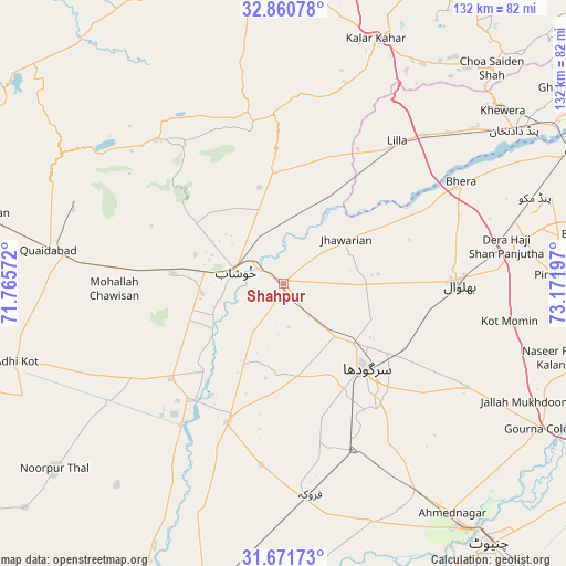
Shahpur GPS coordinates[2]
32° 16' 5.52" North, 72° 28' 7.824" East
| Map corner | latitude | longitude |
|---|---|---|
| Upper-left | 32.86078°, | 71.76572° |
| Center: | 32.2682°, | 72.46884° |
| Lower-right: | 31.67173°, | 73.17197° |
| Map W x H: | 132.2×132.2 km | = 82.1×82.1mi |
| max Lat: | 36.32162° ⇑29.3% North |
| Shahpur: | 32.2682° |
| min Lat: | ⇓70.7% South 24.14422° |
| min Long | Shahpur | max Long |
| 61.74573° | 72.46884° | 75.63372° |
| W 64.1%⇐ | ⇒35.9% E |
Elevation
Elevation of Shahpur is 185 m = 607 ft, and this is 160 m = 525 ft below average elevation for this country.
| Max E: |
2732 m = 8963 ft | 47.2% |
| Avg. | 345 m = 1132 ft | |
| Shahpur | 185 m = 607 ft | |
Min E: |
3 m = 10 ft | 52.8% |
See also: Pakistan elevation on elevation.city.
Geographical zone
Shahpur is located in North temperate zone (between Tropic of Cancer and the Arctic Circle). Distance of this Northern Tropic circle is 982 km =610.2 mi to South.| Distance of | km | miles | from Shahpur |
|---|---|---|---|
| North Pole | 6419.2 | 3988.7 | to North |
| Arctic Circle | 3813.3 | 2369.5 | to North |
| Tropic Cancer | 982 | 610.2 | to South |
| Equator | 3587.9 | 2229.4 | to South |


Nearby cities:
15 places around Shahpur: (largest is in red/bold)
• Bhalwal
40.4 km =25.1 mi,  90°
90°
• Bhera
47.7 km =29.6 mi,  60°
60°
• Faruka
42.8 km =26.6 mi,  186°
186°
• Jahanian Shah
54.5 km =33.9 mi,  199°
199°
• Jauharabad
17.7 km =11 mi,  277°
277°
• Jhawarian
17.8 km =11.1 mi,  54°
54°
• Keshupur
3.1 km =1.9 mi,  107°
107°
• Khushāb
11.4 km =7.1 mi,  286°
286°
• Kot Mumin
53.5 km =33.2 mi,  99°
99°
• Liliani
45.9 km =28.5 mi, 98°
• Mangla
42.5 km =26.4 mi, 191°
• Mitha Tiwana
34.2 km =21.3 mi,  265°
265°
• Sahiwal
35.2 km =21.9 mi, 201°
• Sargodha
28 km =17.4 mi,  136°
136°
• Sillanwali
49.7 km =30.9 mi,  172°
172°
Sources, notices
• [Note1] Compared only with cities in Pakistan existing in our database
• [Src1] Map data: © OpenStreetMap contributors (CC-BY-SA)
• [Src2] Other city data from geonames.org with taken over terms of usage.
• [Src3] Geographical zone / Annual Mean Temperature by Robert A. Rohde @ Wikipedia
