Jand geodata
Jand (Punjab) is a populated place; located in Pakistan in Asia/Karachi (GMT+5) time zone. With population of 18,170 people, there are 282 cities with bigger population in this country. Compared to other cities in Pakistan, 85.1% of cities are located further ↓South; 57.8% of cities are located further ←West and 78.3% of cities have lower elevation than Jand. Note1


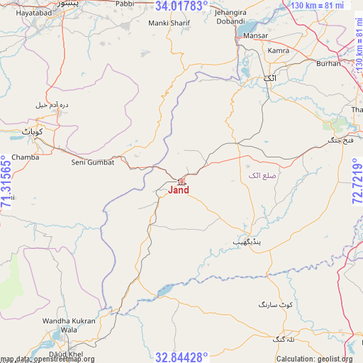
Jand GPS coordinates[2]
33° 25' 58.944" North, 72° 1' 7.572" East
| Map corner | latitude | longitude |
|---|---|---|
| Upper-left | 34.01783°, | 71.31565° |
| Center: | 33.43304°, | 72.01877° |
| Lower-right: | 32.84428°, | 72.7219° |
| Map W x H: | 130.5×130.5 km | = 81.1×81.1mi |
| max Lat: | 36.32162° ⇑14.9% North |
| Jand: | 33.43304° |
| min Lat: | ⇓85.1% South 24.14422° |
| min Long | Jand | max Long |
| 61.74573° | 72.01877° | 75.63372° |
| W 57.8%⇐ | ⇒42.2% E |
Elevation
Elevation of Jand is 345 m = 1132 ft, and this is 0 m = 0 ft above average elevation for this country.
| Max E: |
2732 m = 8963 ft | 21.7% |
| Jand | 345 m 1132 ft | |
| Avg. | 345 m = 1132 ft | |
Min E: |
3 m = 10 ft | 78.3% |
See also: Pakistan elevation on elevation.city.
Geographical zone
Jand is located in North temperate zone (between Tropic of Cancer and the Arctic Circle). Distance of this Northern Tropic circle is 1111.5 km =690.7 mi to South.| Distance of | km | miles | from Jand |
|---|---|---|---|
| North Pole | 6289.7 | 3908.2 | to North |
| Arctic Circle | 3683.8 | 2289 | to North |
| Tropic Cancer | 1111.5 | 690.7 | to South |
| Equator | 3717.4 | 2309.9 | to South |


Nearby cities:
15 places around Jand: (largest is in red/bold)
• Akora
64.2 km =39.9 mi,  8°
8°
• Aman Garh
64.2 km =39.9 mi,  352°
352°
• Attock City
48.7 km =30.3 mi,  40°
40°
• Cherat Cantonement
44.9 km =27.9 mi,  344°
344°
• Hazro City
68.8 km =42.8 mi, 39°
• Kalabagh
68.4 km =42.5 mi,  219°
219°
• Kohat
55.3 km =34.4 mi,  287°
287°
• Lachi
63.5 km =39.5 mi,  264°
264°
• Nowshera
64.9 km =40.3 mi,  356°
356°
• Nowshera Cantonment
62.9 km =39.1 mi, 358°
• Pabbi
67.4 km =41.9 mi, 342°
• Pindi Gheb
31.3 km =19.4 mi,  133°
133°
• Risalpur Cantonment
69.8 km =43.4 mi, 358°
• Sanjwal
52.9 km =32.9 mi,  46°
46°
• Talagang
67.3 km =41.8 mi,  146°
146°
Sources, notices
• [Note1] Compared only with cities in Pakistan existing in our database
• [Src1] Map data: © OpenStreetMap contributors (CC-BY-SA)
• [Src2] Other city data from geonames.org with taken over terms of usage.
• [Src3] Geographical zone / Annual Mean Temperature by Robert A. Rohde @ Wikipedia
