Choa Saidan Shah geodata
Choa Saidan Shah (Punjab) is a populated place; located in Pakistan in Asia/Karachi (GMT+5) time zone. With population of 15,344 people, there are 311 cities with bigger population in this country. Compared to other cities in Pakistan, 79.5% of cities are located further ↓South; 72% of cities are located further ←West and 84.4% of cities have lower elevation than Choa Saidan Shah. Note1


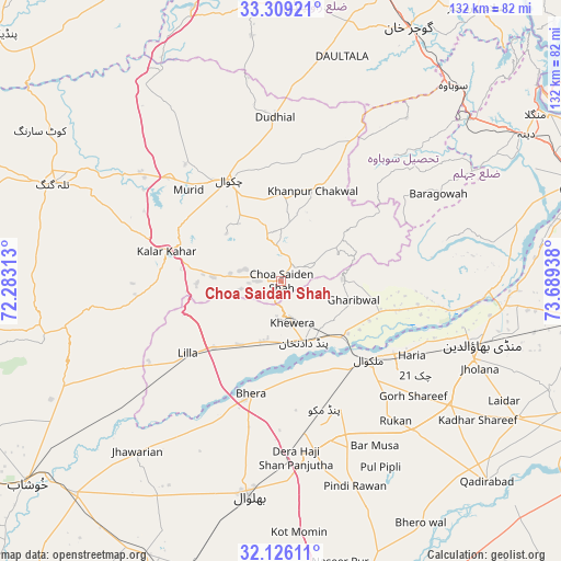
Choa Saidan Shah GPS coordinates[2]
32° 43' 10.632" North, 72° 59' 10.5" East
| Map corner | latitude | longitude |
|---|---|---|
| Upper-left | 33.30921°, | 72.28313° |
| Center: | 32.71962°, | 72.98625° |
| Lower-right: | 32.12611°, | 73.68938° |
| Map W x H: | 131.5×131.5 km | = 81.7×81.7mi |
| max Lat: | 36.32162° ⇑20.5% North |
| Choa Saidan Shah: | 32.71962° |
| min Lat: | ⇓79.5% South 24.14422° |
| min Long | Choa Saidan Sha | max Long |
| 61.74573° | 72.98625° | 75.63372° |
| W 72%⇐ | ⇒28% E |
Elevation
Elevation of Choa Saidan Shah is 625 m = 2051 ft, and this is 280 m = 919 ft above average elevation for this country.
| Max E: |
2732 m = 8963 ft | 15.6% |
| Choa Saidan Shah | 625 m 2051 ft | |
| Avg. | 345 m = 1132 ft | |
Min E: |
3 m = 10 ft | 84.4% |
See also: Pakistan elevation on elevation.city.
Geographical zone
Choa Saidan Shah is located in North temperate zone (between Tropic of Cancer and the Arctic Circle). Distance of this Northern Tropic circle is 1032.2 km =641.4 mi to South.| Distance of | km | miles | from Choa Saidan Shah |
|---|---|---|---|
| North Pole | 6369 | 3957.5 | to North |
| Arctic Circle | 3763.1 | 2338.3 | to North |
| Tropic Cancer | 1032.2 | 641.4 | to South |
| Equator | 3638.1 | 2260.6 | to South |


Nearby cities:
15 places around Choa Saidan Shah: (largest is in red/bold)
• Bhalwal
51.1 km =31.8 mi,  189°
189°
• Bhera
27.4 km =17 mi,  195°
195°
• Chakwal
26.7 km =16.6 mi,  332°
332°
• Dandot RS
8.7 km =5.4 mi, 186°
• Daultala
54.6 km =33.9 mi,  15°
15°
• Dhok Awan
45.4 km =28.2 mi,  287°
287°
• Jhawarian
52.4 km =32.6 mi,  220°
220°
• Kallar Kahar
27.8 km =17.3 mi,  283°
283°
• Khandowa
23.7 km =14.7 mi, 276°
• Khewra
8.2 km =5.1 mi,  163°
163°
• Liliani
57.4 km =35.7 mi,  183°
183°
• Malakwal
28.1 km =17.5 mi,  130°
130°
• Malakwal City
28 km =17.4 mi, 130°
• Mandi Bahauddin
49.5 km =30.8 mi,  107°
107°
• Pind Dadan Khan
15.8 km =9.8 mi, 159°
Sources, notices
• [Note1] Compared only with cities in Pakistan existing in our database
• [Src1] Map data: © OpenStreetMap contributors (CC-BY-SA)
• [Src2] Other city data from geonames.org with taken over terms of usage.
• [Src3] Geographical zone / Annual Mean Temperature by Robert A. Rohde @ Wikipedia
