Khandowa geodata
Khandowa (Punjab) is a populated place; located in Pakistan in Asia/Karachi (GMT+5) time zone. With population of 1,200 people, there are 407 cities with bigger population in this country. Compared to other cities in Pakistan, 79.7% of cities are located further ↓South; 68.6% of cities are located further ←West and 86% of cities have lower elevation than Khandowa. Note1


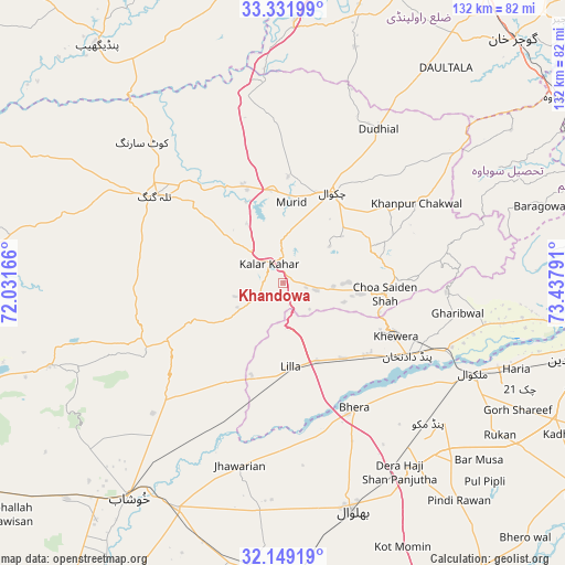
Khandowa GPS coordinates[2]
32° 44' 33.18" North, 72° 44' 5.208" East
| Map corner | latitude | longitude |
|---|---|---|
| Upper-left | 33.33199°, | 72.03166° |
| Center: | 32.74255°, | 72.73478° |
| Lower-right: | 32.14919°, | 73.43791° |
| Map W x H: | 131.5×131.5 km | = 81.7×81.7mi |
| max Lat: | 36.32162° ⇑20.3% North |
| Khandowa: | 32.74255° |
| min Lat: | ⇓79.7% South 24.14422° |
| min Long | Khandowa | max Long |
| 61.74573° | 72.73478° | 75.63372° |
| W 68.6%⇐ | ⇒31.4% E |
Elevation
Elevation of Khandowa is 779 m = 2556 ft, and this is 434 m = 1424 ft above average elevation for this country.
| Max E: |
2732 m = 8963 ft | 14% |
| Khandowa | 779 m 2556 ft | |
| Avg. | 345 m = 1132 ft | |
Min E: |
3 m = 10 ft | 86% |
See also: Pakistan elevation on elevation.city.
Geographical zone
Khandowa is located in North temperate zone (between Tropic of Cancer and the Arctic Circle). Distance of this Northern Tropic circle is 1034.7 km =642.9 mi to South.| Distance of | km | miles | from Khandowa |
|---|---|---|---|
| North Pole | 6366.4 | 3955.9 | to North |
| Arctic Circle | 3760.5 | 2336.7 | to North |
| Tropic Cancer | 1034.7 | 642.9 | to South |
| Equator | 3640.6 | 2262.2 | to South |


Nearby cities:
15 places around Khandowa: (largest is in red/bold)
• Bhalwal
55.2 km =34.3 mi,  163°
163°
• Bhera
33.2 km =20.6 mi,  150°
150°
• Chakwal
23.9 km =14.9 mi,  27°
27°
• Choa Saidan Shah
23.7 km =14.7 mi,  96°
96°
• Dandot RS
25.1 km =15.6 mi,  116°
116°
• Dhok Awan
22.8 km =14.2 mi,  299°
299°
• Jhawarian
43.6 km =27.1 mi,  193°
193°
• Kallar Kahar
5.4 km =3.4 mi,  320°
320°
• Keshupur
58 km =36 mi,  202°
202°
• Khewra
27.8 km =17.3 mi,  111°
111°
• Malakwal
49.4 km =30.7 mi, 115°
• Malakwal City
49.3 km =30.6 mi, 115°
• Pind Dadan Khan
33.8 km =21 mi, 120°
• Shahpur
58.3 km =36.2 mi,  205°
205°
• Talagang
36.2 km =22.5 mi, 304°
Sources, notices
• [Note1] Compared only with cities in Pakistan existing in our database
• [Src1] Map data: © OpenStreetMap contributors (CC-BY-SA)
• [Src2] Other city data from geonames.org with taken over terms of usage.
• [Src3] Geographical zone / Annual Mean Temperature by Robert A. Rohde @ Wikipedia
