Chakwal geodata
Chakwal (Punjab) is a seat of a second-order administrative division; located in Pakistan in Asia/Karachi (GMT+5) time zone. With population of 101,200 people, there are 66 cities with bigger population in this country. Compared to other cities in Pakistan, 81.9% of cities are located further ↓South; 69.3% of cities are located further ←West and 82.4% of cities have lower elevation than Chakwal. Note1


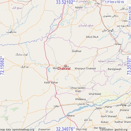
Chakwal GPS coordinates[2]
32° 55' 58.296" North, 72° 51' 14.184" East
| Map corner | latitude | longitude |
|---|---|---|
| Upper-left | 33.52102°, | 72.15082° |
| Center: | 32.93286°, | 72.85394° |
| Lower-right: | 32.34076°, | 73.55707° |
| Map W x H: | 131.2×131.2 km | = 81.5×81.5mi |
| max Lat: | 36.32162° ⇑18.1% North |
| Chakwal: | 32.93286° |
| min Lat: | ⇓81.9% South 24.14422° |
| min Long | Chakwal | max Long |
| 61.74573° | 72.85394° | 75.63372° |
| W 69.3%⇐ | ⇒30.7% E |
Elevation
Elevation of Chakwal is 523 m = 1716 ft, and this is 178 m = 584 ft above average elevation for this country.
| Max E: |
2732 m = 8963 ft | 17.6% |
| Chakwal | 523 m 1716 ft | |
| Avg. | 345 m = 1132 ft | |
Min E: |
3 m = 10 ft | 82.4% |
See also: Chakwal elevation on elevation.city.
Geographical zone
Chakwal is located in North temperate zone (between Tropic of Cancer and the Arctic Circle). Distance of this Northern Tropic circle is 1055.9 km =656.1 mi to South.| Distance of | km | miles | from Chakwal |
|---|---|---|---|
| North Pole | 6345.3 | 3942.8 | to North |
| Arctic Circle | 3739.4 | 2323.6 | to North |
| Tropic Cancer | 1055.9 | 656.1 | to South |
| Equator | 3661.8 | 2275.3 | to South |


Nearby cities:
15 places around Chakwal: (largest is in red/bold)
• Bhera
50.4 km =31.3 mi,  174°
174°
• Choa Saidan Shah
26.7 km =16.6 mi,  152°
152°
• Dandot RS
34.3 km =21.3 mi,  160°
160°
• Daultala
39.4 km =24.5 mi,  42°
42°
• Dhok Awan
32.4 km =20.1 mi,  252°
252°
• Gujar Khan
55.1 km =34.2 mi,  49°
49°
• Jhawarian
67.1 km =41.7 mi,  198°
198°
• Kallar Kahar
22.4 km =13.9 mi,  220°
220°
• Khandowa
23.9 km =14.9 mi,  207°
207°
• Khewra
34.8 km =21.6 mi, 155°
• Malakwal
53.8 km =33.4 mi,  141°
141°
• Malakwal City
53.7 km =33.4 mi, 141°
• Pind Dadan Khan
42.4 km =26.3 mi, 155°
• Pindi Gheb
64.7 km =40.2 mi,  301°
301°
• Talagang
40.9 km =25.4 mi,  269°
269°
Sources, notices
• [Note1] Compared only with cities in Pakistan existing in our database
• [Src1] Map data: © OpenStreetMap contributors (CC-BY-SA)
• [Src2] Other city data from geonames.org with taken over terms of usage.
• [Src3] Geographical zone / Annual Mean Temperature by Robert A. Rohde @ Wikipedia
