Kohat geodata
Kohat (Khyber Pakhtunkhwa) is a seat of a second-order administrative division; located in Pakistan in Asia/Karachi (GMT+5) time zone. With population of 151,427 people, there are 43 cities with bigger population in this country. Compared to other cities in Pakistan, 86% of cities are located further ↓South; 50.3% of cities are located further →East and 82.2% of cities have lower elevation than Kohat. Note1


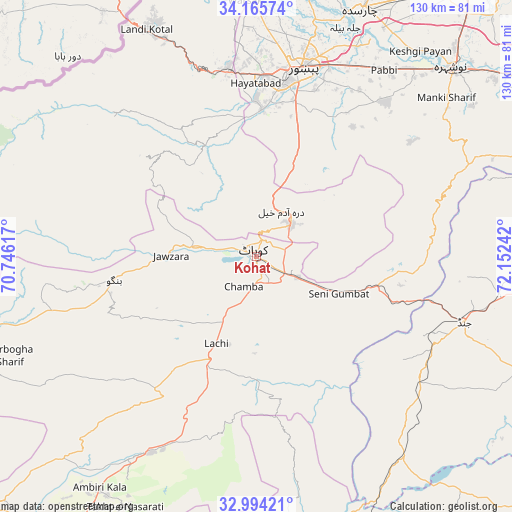
Kohat GPS coordinates[2]
33° 34' 55.056" North, 71° 26' 57.444" East
| Map corner | latitude | longitude |
|---|---|---|
| Upper-left | 34.16574°, | 70.74617° |
| Center: | 33.58196°, | 71.44929° |
| Lower-right: | 32.99421°, | 72.15242° |
| Map W x H: | 130.3×130.3 km | = 81×81mi |
| max Lat: | 36.32162° ⇑14% North |
| Kohat: | 33.58196° |
| min Lat: | ⇓86% South 24.14422° |
| min Long | Kohat | max Long |
| 61.74573° | 71.44929° | 75.63372° |
| W 49.7%⇐ | ⇒50.3% E |
Elevation
Elevation of Kohat is 503 m = 1650 ft, and this is 158 m = 518 ft above average elevation for this country.
| Max E: |
2732 m = 8963 ft | 17.8% |
| Kohat | 503 m 1650 ft | |
| Avg. | 345 m = 1132 ft | |
Min E: |
3 m = 10 ft | 82.2% |
See also: Kohat elevation on elevation.city.
Geographical zone
Kohat is located in North temperate zone (between Tropic of Cancer and the Arctic Circle). Distance of this Northern Tropic circle is 1128 km =700.9 mi to South.| Distance of | km | miles | from Kohat |
|---|---|---|---|
| North Pole | 6273.1 | 3897.9 | to North |
| Arctic Circle | 3667.2 | 2278.7 | to North |
| Tropic Cancer | 1128 | 700.9 | to South |
| Equator | 3734 | 2320.2 | to South |


Nearby cities:
15 places around Kohat: (largest is in red/bold)
• Aman Garh
64.7 km =40.2 mi,  43°
43°
• Charsadda
68.5 km =42.6 mi,  23°
23°
• Cherat Cantonement
49 km =30.4 mi,  56°
56°
• Doaba
68.3 km =42.4 mi,  255°
255°
• Hangu
36.5 km =22.7 mi, 261°
• Jand
55.3 km =34.4 mi,  107°
107°
• Kalabagh
69.6 km =43.2 mi,  172°
172°
• Karak
61.4 km =38.2 mi,  212°
212°
• Lachi
24.4 km =15.2 mi, 205°
• Landi Kotal
64.1 km =39.8 mi,  333°
333°
• Nowshera
68.9 km =42.8 mi,  45°
45°
• Nowshera Cantonment
68.7 km =42.7 mi, 47°
• Pabbi
57.3 km =35.6 mi,  33°
33°
• Peshawar
48.9 km =30.4 mi,  14°
14°
• Shabqadar
71.2 km =44.2 mi, 7°
Sources, notices
• [Note1] Compared only with cities in Pakistan existing in our database
• [Src1] Map data: © OpenStreetMap contributors (CC-BY-SA)
• [Src2] Other city data from geonames.org with taken over terms of usage.
• [Src3] Geographical zone / Annual Mean Temperature by Robert A. Rohde @ Wikipedia
