Pad Idan geodata
Pad Idan (Sindh) is a populated place; located in Pakistan in Asia/Karachi (GMT+5) time zone. With population of 20,919 people, there are 267 cities with bigger population in this country. Compared to other cities in Pakistan, 83.3% of cities are located further ↑North; 82.8% of cities are located further →East and 83.5% of cities have higher elevation than Pad Idan. Note1


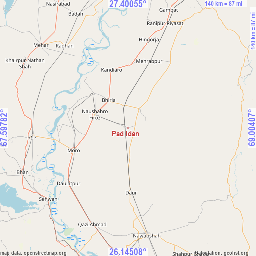
Pad Idan GPS coordinates[2]
26° 46' 28.38" North, 68° 18' 3.384" East
| Map corner | latitude | longitude |
|---|---|---|
| Upper-left | 27.40055°, | 67.59782° |
| Center: | 26.77455°, | 68.30094° |
| Lower-right: | 26.14508°, | 69.00407° |
| Map W x H: | 139.6×139.6 km | = 86.7×86.7mi |
| max Lat: | 36.32162° ⇑83.3% North |
| Pad Idan: | 26.77455° |
| min Lat: | ⇓16.7% South 24.14422° |
| min Long | Pad Idan | max Long |
| 61.74573° | 68.30094° | 75.63372° |
| W 17.2%⇐ | ⇒82.8% E |
Elevation
Elevation of Pad Idan is 49 m = 161 ft, and this is 296 m = 971 ft below average elevation for this country.
| Max E: |
2732 m = 8963 ft | 83.5% |
| Avg. | 345 m = 1132 ft | |
| Pad Idan | 49 m = 161 ft | |
Min E: |
3 m = 10 ft | 16.5% |
See also: Pakistan elevation on elevation.city.
Geographical zone
Pad Idan is located in North temperate zone (between Tropic of Cancer and the Arctic Circle). Distance of this Northern Tropic circle is 371.1 km =230.6 mi to South.| Distance of | km | miles | from Pad Idan |
|---|---|---|---|
| North Pole | 7030 | 4368.2 | to North |
| Arctic Circle | 4424.1 | 2749 | to North |
| Tropic Cancer | 371.1 | 230.6 | to South |
| Equator | 2977.1 | 1849.9 | to South |


Nearby cities:
15 places around Pad Idan: (largest is in red/bold)
• Bandhi
20.8 km =12.9 mi,  179°
179°
• Bhiria
18.4 km =11.4 mi,  325°
325°
• Dadu
52.3 km =32.5 mi,  264°
264°
• Darya Khan Marri
10.9 km =6.8 mi,  187°
187°
• Daulatpur
44.7 km =27.8 mi,  227°
227°
• Daur
35.5 km =22.1 mi, 177°
• Hingorja
49.8 km =30.9 mi,  13°
13°
• Kandiari
26.9 km =16.7 mi,  54°
54°
• Kandiaro
32.9 km =20.4 mi,  344°
344°
• Karaundi
17.2 km =10.7 mi,  37°
37°
• Moro
32.3 km =20.1 mi,  247°
247°
• Naushahro Firoz
19.1 km =11.9 mi,  292°
292°
• Setharja Old
51.5 km =32 mi,  18°
18°
• Sīta Road
53.2 km =33.1 mi,  302°
302°
• Tharu Shah
26.1 km =16.2 mi,  315°
315°
Sources, notices
• [Note1] Compared only with cities in Pakistan existing in our database
• [Src1] Map data: © OpenStreetMap contributors (CC-BY-SA)
• [Src2] Other city data from geonames.org with taken over terms of usage.
• [Src3] Geographical zone / Annual Mean Temperature by Robert A. Rohde @ Wikipedia
