Sīta Road geodata
Sīta Road (Sindh) is a populated place; located in Pakistan in Asia/Karachi (GMT+5) time zone. With population of 27,587 people, there are 224 cities with bigger population in this country. Compared to other cities in Pakistan, 81.5% of cities are located further ↑North; 90.5% of cities are located further →East and 85.3% of cities have higher elevation than Sīta Road. Note1


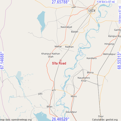
Sīta Road GPS coordinates[2]
27° 1' 59.988" North, 67° 51' 0" East
| Map corner | latitude | longitude |
|---|---|---|
| Upper-left | 27.65788°, | 67.14688° |
| Center: | 27.03333°, | 67.85° |
| Lower-right: | 26.40529°, | 68.55313° |
| Map W x H: | 139.3×139.3 km | = 86.6×86.6mi |
| max Lat: | 36.32162° ⇑81.5% North |
| Sīta Road: | 27.03333° |
| min Lat: | ⇓18.5% South 24.14422° |
| min Long | Sīta Road | max Long |
| 61.74573° | 67.85° | 75.63372° |
| W 9.5%⇐ | ⇒90.5% E |
Elevation
Elevation of Sīta Road is 44 m = 144 ft, and this is 301 m = 988 ft below average elevation for this country.
| Max E: |
2732 m = 8963 ft | 85.3% |
| Avg. | 345 m = 1132 ft | |
| Sīta Road | 44 m = 144 ft | |
Min E: |
3 m = 10 ft | 14.7% |
See also: Pakistan elevation on elevation.city.
Geographical zone
Sīta Road is located in North temperate zone (between Tropic of Cancer and the Arctic Circle). Distance of this Northern Tropic circle is 399.9 km =248.5 mi to South.| Distance of | km | miles | from Sīta Road |
|---|---|---|---|
| North Pole | 7001.2 | 4350.3 | to North |
| Arctic Circle | 4395.3 | 2731.1 | to North |
| Tropic Cancer | 399.9 | 248.5 | to South |
| Equator | 3005.8 | 1867.7 | to South |


Nearby cities:
15 places around Sīta Road: (largest is in red/bold)
• Bhiria
36.8 km =22.9 mi,  111°
111°
• Dadu
34.5 km =21.4 mi,  192°
192°
• Dokri
45.1 km =28 mi,  32°
32°
• Goth Phulji
23.7 km =14.7 mi,  224°
224°
• Goth Radhan
21 km =13 mi, 29°
• Johi
44.6 km =27.7 mi,  211°
211°
• Kandiaro
35.8 km =22.2 mi,  85°
85°
• Khairpur Nathan Shah
13.1 km =8.1 mi,  299°
299°
• Mehar
16.6 km =10.3 mi,  349°
349°
• Moro
43.8 km =27.2 mi,  160°
160°
• Nasirabad
39.3 km =24.4 mi,  9°
9°
• Naushahro Firoz
34.5 km =21.4 mi,  128°
128°
• New Bādāh
38.7 km =24 mi, 27°
• Tharu Shah
28.4 km =17.6 mi, 110°
• Warah
46.4 km =28.8 mi, 353°
Sources, notices
• [Note1] Compared only with cities in Pakistan existing in our database
• [Src1] Map data: © OpenStreetMap contributors (CC-BY-SA)
• [Src2] Other city data from geonames.org with taken over terms of usage.
• [Src3] Geographical zone / Annual Mean Temperature by Robert A. Rohde @ Wikipedia
