Tharu Shah geodata
Tharu Shah (Sindh) is a populated place; located in Pakistan in Asia/Karachi (GMT+5) time zone. With population of 17,698 people, there are 285 cities with bigger population in this country. Compared to other cities in Pakistan, 81.9% of cities are located further ↑North; 86% of cities are located further →East and 83.5% of cities have higher elevation than Tharu Shah. Note1


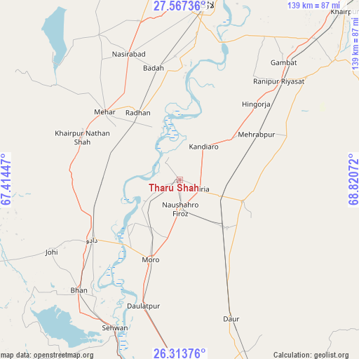
Tharu Shah GPS coordinates[2]
26° 56' 32.28" North, 68° 7' 3.324" East
| Map corner | latitude | longitude |
|---|---|---|
| Upper-left | 27.56736°, | 67.41447° |
| Center: | 26.9423°, | 68.11759° |
| Lower-right: | 26.31376°, | 68.82072° |
| Map W x H: | 139.4×139.4 km | = 86.6×86.6mi |
| max Lat: | 36.32162° ⇑81.9% North |
| Tharu Shah: | 26.9423° |
| min Lat: | ⇓18.1% South 24.14422° |
| min Long | Tharu Shah | max Long |
| 61.74573° | 68.11759° | 75.63372° |
| W 14%⇐ | ⇒86% E |
Elevation
Elevation of Tharu Shah is 49 m = 161 ft, and this is 296 m = 971 ft below average elevation for this country.
| Max E: |
2732 m = 8963 ft | 83.5% |
| Avg. | 345 m = 1132 ft | |
| Tharu Shah | 49 m = 161 ft | |
Min E: |
3 m = 10 ft | 16.5% |
See also: Pakistan elevation on elevation.city.
Geographical zone
Tharu Shah is located in North temperate zone (between Tropic of Cancer and the Arctic Circle). Distance of this Northern Tropic circle is 389.8 km =242.2 mi to South.| Distance of | km | miles | from Tharu Shah |
|---|---|---|---|
| North Pole | 7011.4 | 4356.7 | to North |
| Arctic Circle | 4405.5 | 2737.4 | to North |
| Tropic Cancer | 389.8 | 242.2 | to South |
| Equator | 2995.7 | 1861.4 | to South |


Nearby cities:
15 places around Tharu Shah: (largest is in red/bold)
• Bandhi
43.5 km =27 mi,  155°
155°
• Bhiria
8.4 km =5.2 mi,  114°
114°
• Dadu
41.2 km =25.6 mi,  235°
235°
• Darya Khan Marri
33.9 km =21.1 mi,  150°
150°
• Goth Radhan
32.8 km =20.4 mi,  330°
330°
• Hingorja
42 km =26.1 mi,  44°
44°
• Kandiari
40.2 km =25 mi,  94°
94°
• Kandiaro
15.9 km =9.9 mi, 35°
• Karaundi
29.1 km =18.1 mi,  99°
99°
• Khairpur Nathan Shah
41.3 km =25.7 mi,  293°
293°
• Mehar
39.6 km =24.6 mi,  311°
311°
• Moro
33.2 km =20.6 mi,  200°
200°
• Naushahro Firoz
11.4 km =7.1 mi,  177°
177°
• Pad Idan
26.1 km =16.2 mi,  135°
135°
• Sīta Road
28.4 km =17.6 mi, 290°
Sources, notices
• [Note1] Compared only with cities in Pakistan existing in our database
• [Src1] Map data: © OpenStreetMap contributors (CC-BY-SA)
• [Src2] Other city data from geonames.org with taken over terms of usage.
• [Src3] Geographical zone / Annual Mean Temperature by Robert A. Rohde @ Wikipedia
